Click for Free
Calendar
Event Submission
Click here for your![]()
basic Portal listing!
FIRST CHOICE SHUTTERS
& BLINDS
![]()
Serving South-Central Texas
Quality window treatments
Plantation shutters, blinds, screens, shades
Wood and faux wood available
Made in America
Locally owned & operated:
Tim & Barbara Van Tassel
830-201-2151
timgvant@hotmail.com
Johnson City, TX
Call, email or text with questions or to arrange a no-obligation visit and quotation at your place.
Facebook

COFRAN'S PC &
TECHNOLOGY HELP
- - -
Online, Remote
Tech Support &
Call-In Help Desk
Virus? Frustrated?
PC slowed down?
We can tune it up!
Internet, Wi-Fi,
Websites,
Email, Outlook,
Social Media,
Tech Marketing,
Excel, Quickbooks,
Zoom, TeamViewer,
Carbonite
** PC Repairs **
BSEE, MBA, xCPA
Veteran, Tech Officer
281-300-7177
Johnson City
info@cofran.com
www.cofran.com
"The Web Guy"
WEB SITE DESIGN
& MAINTENANCE
Economical
& Effective
281-300-7177
Johnson City, TX
info@cofran.com
cofran.com
"Business Coach"
COST CONTROLS,
EFFICIENCY &
BETTER STRATEGIES
= MORE PROFIT !!
Economical
& Effective
281-300-7177
Johnson City, TX
info@cofran.com
cofran.com

Cofran's Texas . . .
Hill Country Portal
A Powerful Information Database & Gateway Service for the Texas Hill Country
Focus Topic Profile For:
WEATHER, CLIMATE, SUN, MOON, TIME, SOLAR & TERRESTRIAL DATA
FOR THE TEXAS HILL COUNTRY
 This handy resource will allow you to quickly find the on-line weather resources best suited to your needs. The scope include severe weather and the more routine day-to-day weather reporting, as well as climate, sun, moon, time and terrestrial information.
When weather sources and government officials issue warnings regarding significant weather events, please heed these warnings for your own safety. Be especially careful about the dangers of rising water.
Also see our related Hill Country Portal focus page on Emergencies, and the related sections regarding severe weather.
Many of these weather services also have email-based alert/notification apps. Be sure to also see our list of Hill Country specific regional Alert/Notification systems and consider signing up for these free alerts.
We welcome inquiries, comments and submission of updates, additions, corrections & digital photos,
without compensation. Send to Editor at:
editor@HillCountryPortal.com
- National Hurricane Center (NHC)
- Weather Reporting & Forecasting Tools
- Water & Flooding In Hill Country
- Heat Conditions In Hill Country
- Drought Conditions & Management In Hill Country
- Fire Conditions In Hill Country
- Wind & Air Conditions In Hill Country
- NOAA/NWS Local Weather Forecasts
for Larger Towns In Hill Country - Very Nearby Weather Reporting
- Local And World-wide Time
- Other Terrestrial & Solar Data
- Storm Wind Scale
- Historical Weather Data
- Participate
NATIONAL HURRICANE CENTER (NHC): nhc.noaa.gov
- Atlantic/Gulf Tropical Cyclone Activity: Current
- Atlantic/Gulf Tropical Cyclone Activity: 2 Day Outlook
- Atlantic/Gulf Tropical Cyclone Activity: 7 Day Outlook
- US Gulf Coast & Inland: Watches/Warnings and 5-Day Forecast Cone for Storm Center
- Hurricane Resources: Details, Current Satellite Imagery
THE EYE WALL: theeyewall.com. This site is all about hurricane season, predictions, preparedness and the technology behind hurricane weather forecasting.
KNOW THE DIFFERENCE: >>>>
SEVERE THUNDERSTORM WATCH: VS.
• Severe storms are possible.
• Be prepared.
• Conditions are likely for
severe thunderstorms capable of
producing large hail or damaging winds.
• Stay tuned to local radio/TV for info.
TORNADO WATCH: VS.
• A tornado is possible.
• Know where you will shelter.
• Stay tuned to local radio/TV for info.
SEVERE THUNDERSTORM WARNING:
• Severe storms HAVE developed.
• Large hail or damaging wind is occurring
or will happen shortly.
• Seek shelter.
TORNADO WARNING:
• A tornado is happening or imminent.
• Take shelter immediately.
TORNADO STRENGTH
- EF0 Tornado: 65 to 85 MPH Wind Gusts >> Weak
- EF1 Tornado: 86 to 110 MPH Wind Gusts >> Weak
- EF2 Tornado: 111 to 135 MPH Wind Gusts >>Strong
- EF3 Tornado: 136 to 165 MPH Wind Gusts >> Strong
- EF4 Tornado: 166 to 200 MPH Wind Gusts >> Violent
- EF5 Tornado: Anything Over 200 MPH Wind Gusts >> Violent
 NATIONAL WEATHER SERVICE (NWS): weather.gov. NWS is part of NOAA and receives funding from the US Dept of Commerce. NWS has 100 offices throughout the US, and they are operational 24x7. These offices issue weather advisories and warnings as they become available.
- Local NOAA Weather Forecast Office for Austin/San Antonio greater area: Forecast Desk: 830-606-3617; 2090 Airport Rd, New Braunfels, TX 78130
weather.gov/ewx. Tracks weather for 33 surrounding counties. nws.sanantonio@noaa.gov - Storm Prediction Center: spc.noaa.gov
- Radar Image (Past 1 hr loop): Austin/San Antonio
- Satellite Image: Eastern/Central US, US
- Observed Precipitation: Map
- Forecast: Weather Pattern Graphic
- Forecast: Temperature
- Forecast: Sky Cover
- NOAA "All Hazards" Weather Radio Service (NWR): Details. Note, this NOAA FM broadcast service is not in the frequency range of the typical home FM receiver, and is usually tunable only on marine, commercial and special "emergency radios". Transmissions are on following frequencies: 162.400, 162.425, 162.450, 162.475, 162.500, 162.525, 162.550 MHz. In the Texas Hill Country, transmitters are located in Austin, Junction, Kerrville, Llano, Richland Springs, San Antonio, and Uvalde, as well as nearby in D'Hanis, Gonzales, and Seguin.
- Interactive Weather: Radar
- Severe Weather: Severe Weather Outlook
WORLD WEATHER CONDITIONS: Conditions. Includes temperature, perceived temperature, precipitation, radar, satellite, clouds, wind speed and gusts, air pressure, thunderstorms, humidity, waves, snow cover, air quality.
COMMUNITY COLLABORATIVE RAIN, HAIL & SNOW NETWORK (CoCoRaHS): cocorahs.org, "Volunteers working together to measure precipitation across the nations."
SEISMIC MONITOR: ds.iris.edu/seismon. Interactive display of earthquakes; zoom from worldwide to local, for today, yesterday and through past 5 years.
OTHER NATIONAL WEATHER REPORTING WEB SITES: Since weather presentation can be very different from one service to the next, take your pick from these major weather reporters: accuweather.com; intellicast.com; weather.com; weatherplaza.com
Note, most of these services obtain their core weather data from NOAA/NWS, and often augment that with local radar and weather spotter sources.
EMERGENCY ALERT SYSTEMS: Some of the regional Council Of Governments (See COG) organizations provide a free alert system covering public emergencies and weather. They send alerts to your choice of destinations: email, phone, text, etc.
- CAPCOG Emergency Alert System: Warn Central Texas, Code Red:
512-916-6000; Web. Counties Served: Bastrop, Blanco, Burnet, Caldwell, Fayette, Hays, Lee, Llano, Travis, Williamson. - CTCOG Code Red Emergency Alerts: 836-939-0911; Web Sign-Up. Counties Served: Bell, Coryell, Hamilton, Lampasas, Milam, Mills, San Saba.
- AUSTIN:
- SAN ANTONIO:
- OTHERS:
- SPACE CITY (Houston): Weather

USGS TEXAS WATER DASHBOARD: txpub.usgs.gov/txwaterdashboard. Texas Water Science Center. Reporting on rain, flooding. Maps. Graphic Water Information System (GWIS). Lower Colorado Drought Visualization Story map.
COMMUNITY COLLABORATE RAIN, HAIL & SNOW NETWORK (CoCoRaHS): maps.cocorahs.org/. Precipitation reporting on maps.
ATX FLOODING, LOW WATER CROSSING CLOSURE & ROAD CLOSURES: ATXFloods.com. Covers: Caldwell County, Cedar Park, Hays County, Leander, Marble Falls, Rollingwood, Round Rock, Sunset Valley, Travis County, Williamson County (and Caldwell & Bastrop counties). Alert system available.
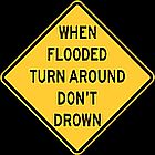
TURN AROUND DON'T DROWN: Safety Program regarding flooding
WATER RESOURCES: Also see our Focus Topic page on Water in the Hill Country, regarding lakes, rivers, streams, groundwater, conservation, and more.
HEAT.GOV: The Interagency National Integrated Heat Health Information System (NIHHIS) provides the public and decision-makers with clear, timely and science-based information to understand and reduce the health risks of extreme heat. See heat.gov
NWS HEAT RISK: An experimental color-numeric-based index that provides a forecast risk of heat-related impacts to occur over a 24-hour period. HeatRisk takes into consideration: How unusual the heat is for the time of the year, The duration of the heat including both daytime and nighttime temperatures; If those temperatures pose an elevated risk of heat-related impacts based on data from the CDC.
This index is supplementary to official NWS heat products and is meant to provide risk guidance for those decision makers and heat-sensitive populations who need to take actions at levels that may be below current NWS heat product levels. See wpc.ncep.noaa.gov/heatrisk
HEAT INDEX: Did you know it can feel hotter than the air temperature - because of humidity? This index is a measure of how hot it really feels when relative humidity is factored in with the actual air temperature. To find the Heat Index temperature, look at the NWS Heat Index Chart or see the Heat Index Calculator at weather.gov/safety/heat-index
WET BULB GLOBE TEMPERATURE (WBGT): A heat indicator for healthy, outdoor, active populations! See forecasted WBGT and lots more on heat at digital.mdl.nws.noaa.gov
Various state agencies support drought response in Texas through their own work and through collaborative efforts as part of councils, task forces, and other collective endeavors.
TEXAS DIVISION OF EMERGENCY MANAGEMENT (TDEM): TDEM coordinates the state emergency management program, which is intended to ensure the state and its local governments respond to and recover from emergencies and disasters and implement plans and programs to help prevent or lessen the impact of emergencies and disasters. The chief of TDEM is the state drought manager and is responsible for managing and coordinating the drought response component of the state water plan. tdem.texas.gov
TEXAS DROUGHT PREPAREDNESS COUNCIL: The TWDB is a member of the Council, which is charged with preparing the state's Drought Preparedness Plan and situation reports that are delivered to state leadership. The Council also coordinates drought-response planning efforts of local, state, and federal agencies; advises the governor on significant drought conditions and recommends counties for inclusion in state drought disaster declarations; and prepares a report on drought across the state for the Texas Legislature every two years. tdem.texas.gov/about/temac
TEXAS COMMISSION ON ENVIRONMENTAL QUALITY (TCEQ): The TCEQ provides hands-on assistance to communities responding to drought and provides robust drought information on its website. tceq.texas.gov/response/drought
TEXAS WATER DEVELOPMENT BOARD (TWDB): The TWDB not only provides information on drought and water resources but can also provide financial assistance to help communities respond to drought. twdb.texas.gov/drought/response/index.asp, twdb.texas.gov/publications/shells/doc/Droughtresources.pdf
TEXAS DEPARTMENT OF AGRICULTURE (TDA): TDA may have grants to assist rural communities struggling with drought. texasagriculture.gov/GrantsServices.aspx
TEXAS WATER INFRASTRUCTURE COORDINATION COMMITTEE: The Committee is made up of state and federal funding agencies, technical assistance providers, and other members of the water community and works with entities across Texas to identify and develop solutions to water challenges, including those brought on by drought. twicc.org
TOOL FOR PLANNING WATER SUPPLY RESPONSE IN DROUGHT EMERGENCIES: This tool is offered to support water resource and utility professionals with the challenge of providing water to communities under the influence of severe drought. The tool's objective is to assist in planning for water shortages by familiarizing users with alternative sources, treatment processes, distribution options, short-term equipment solutions for treatment, and the regulatory process as it relates to emergency drought situations. twdb.texas.gov/innovativewater/doc/emergency_water_tool.pdf
STATE OF TEXAS DROUGHT ANNEX: The State of Texas Drought Annex is prepared by the Drought Preparedness Council and serves as the drought-focused component of the State of Texas Emergency Management Plan. waterdatafortexas.org/drought/twdb-reports/state_of_texas_drought_annex_2016.pdf
NOAA DROUGHT REPORTING - NATIONAL CENTERS FOR ENVIORONMENTAL INFORMATION: Data archive & access, ncei.noaa.gov
PALMER HYDROLOGICAL DROUGHT INDEX (PHDI): Index Background, PHDI and Drought.gov Maps; and Current/Projected Condition Maps. Part of the suite of indices developed by Palmer in the 1960s with the United States Weather Bureau. Based on the original PDSI and modified to take into account longer-term dryness that will affect water storage, streamflow and groundwater. PHDI has the ability to calculate when a drought will end based on precipitation needed by using a ratio of moisture received to moisture required to end a drought. There are four drought categories: near normal, which occurs approximately 28%–50% percent of the time; mild to moderate, which occurs approximately 11%–27% percent of the time; severe, which occurs approximately 5%–10% percent of the time; and extreme, which will occur approximately 4% of the time.
US DROUGHT MONITOR: Produced through a partnership between the National Drought Mitigation Center at the University of Nebraska-Lincoln, the United States Department of Agriculture, and the National Oceanic and Atmospheric Administration. 402-472–6707; Note, this monitor monitor focuses on broad-scale conditions. Local conditions may vary. US Drought Map; Southern US; Texas
TEXAS A&M FOREST SERVICE (TFS) PREDICTIVE SERVICES: Fire Conditions in Texas, including: Current Observed Fire Danger Map; Current Keetch-Bryam Drought Index Map; Current Outdoor Burn Bans by County. Much other helpful wildfire-related information is at this website.
WILDFIRE PREPARATION - How To: Red Cross Guidance
FIREWISE: nfpa.org/Education-and-Research/Wildfire/Firewise. This NFPA's program teaches people how to adapt to living with wildfire and encourages neighbors to work together and take action. Includes a variety of resources to assist homeowners, program participants, and other wildfire stakeholders as they travel down the path to wildfire risk reduction.
KEETCH-BYRAM DROUGHT INDEX (KBDI): Produced by the US Forest Service, this index assesses the risk of fire by representing the net effect of evapotranspiration and precipitation in producing cumulative moisture deficiency in deep duff and upper soil layers. It estimates how dry the soil and duff layers are. The index ranges from 0 (no moisture deficit) to 800 (maximum drought), representing a moisture regime from 0 to 8 inches of water through the soil layer. At 8 inches of water, the KBDI assumes saturation. Any point along the scale indicates the amount of net rainfall required to reduce the index to zero or saturation1.
TEXAS WILDFIRE INCIDENT RESPONSE SYSTEM & VIEWER: public.tfswildfires.com, from TFS, the Incident Viewer displays current status of wildfires in Texas. Wildfire incidents that are closed are not shown.
INCIWEB INCIDENT VIEWER: inciweb.nwcg.gov. An inter-agency, all-risk, incident information management system developed to provide the public a single source of incident related information; and to provide a standardized reporting tool for the Public Affairs community.
WATCH DUTY: An excellent, well updated, map display and specifics on active fires in the USA. On-line alert feature. Available on the web at: app.watchduty.org, and as a cell phone app: "Watch Duty".
AIR NOW - FIRE & SMOKE: fire.airnow.gov
GOOGLE MAPS WILDFIRE LAYER: Like the Google Air Quality Index layer now available on Google Maps, you can add a "Wildfire Layer" on your maps to show active fires with data provided by the National Interagency Fire Center. See Air Quality reporting above for details on how to select "layers" on Google Maps
WIND CONDITIONS: Ventusky: World-wide Wind. Read more about Wind and about Wind Power
AIR QUALITY - NWS: hweather.gov/safety/airquality
AIRNOW: Daily air pollution forcasts by area. Maps includes real-time data on current pollution levels. airnow.gov. Also includes background information on air quality and the natiioal AQI.
AIR QUALITY INDEX (AQI) - LUNG.ORG: Web. Presented by American Lung Assn.
AIR QUALITY-GOOGE MAPS: Air Quality Index (AQI), via Google Maps with its new Air Quality layer. Simply click the “Layers” menu icon (same button in loweer left corner you would use to change mode to satellite or street view). It provides an option to include AQI numbers on the map. Click on an AQI and it will show the sources and timing for that data. The format of the AQI is a number from 0 to 500, with the quality decreasing as the number goes up. The AQI includes smoke contributions as reported by the NOAA.
POLLEN COUNT FORECAST: pollen.com/forecast.asp. Enter city or zip code to narrow results to your specific geographic area of interest. Options for extended forecasts, and alert system.
DUST: See World Meteorological Organization dust information background, health factors, forecasts and bulletins at public.wmo.int/en/our-mandate/focus-areas/environment/sand-and-dust-storms. See forecasts from WMO Sand and Dust Storm Warning Advisory and Assessment System (SDS-WAS) at sds-was.cimh.edu.bb/
LARGE SEASONAL DUST PLUMES: Significant dust plume occur annually and seasonally, arriving here in our Spring through Summer seasons. The plumes complete the 5,000 mile journey from Africa to Texas, carrying some 180 million tons of Saharan desert dust across the Atlantic each year. These plumes play an important role in nature. This dust helps fertilize by transporting minerals such as iron and phosphorus. The particles making these plumes of dust are very small, about 1-2.5 micrometers. These hot, dry particles are respiratory irritants, so air quality is reduced when you are surrounded by thick plumes. A plume will often have enough dust in it to drop our air quality to the "moderate" range, meaning that while it likely is hazy outside, the average person won't even notice an impact on their breathing. However, those with very sensitive or compromised respiratory function might experience complications and may want to reduce their time outdoors.
AIR POLLUTION WORLD-WIDE VIDEO: View. Stunning NASA video of GEOS5 aerosols (in color, on YouTube), indicating that "air pollution from Asia strengthens extratropical cyclones, a type of storm system that drives much of our country's weather". Video shows pollution streams over a multi-year period indicated by the dates displayed.
FOR LARGER TOWNS IN HILL COUNTRY

LOCAL FORECASTS: weather.gov. Simply enter your town/city name to obtain a weather summary. Click "Get Detailed Information" if you want more details.
WEATHER UNDERGROUND: wunderground.com. Weather reporting and forecasts customizable to your nearest neighborhood participating data reporting station. Plus a full and excellent suite of weather information services.
TIME & DATE: Extensive world time zone displays, location date & time, calendars, clocks, calculators, apps and more, at: Time & Date
US NAVAL OBSERVATORY DATA: aa.usno.navy.mil/data/index. Excellent data resource for: Rise/Set/Transit/Twilight Data; Phases of the Moon; Eclipses and Transits; Positions of Selected Celestial Objects; Dates and Times; Celestial Navigation. Definitions and explanations for the above are included at the USNO web site.
WHAT THE MOON LOOKS LIKE AT THIS MOMENT: Die Real Time; Moon Giant
DAY & NIGHT ACROSS THE EARTH, INTERACTIVE: Fourmilab View; Sunmap, Sunlight
NATIONAL RADIATION: Map depicting environmental radiation levels across the USA, updated in real time every minute.
THE SKY ABOVE YOU, INTERACTIVE PLANETARIUM: Shows the entire sky as viewed from a given location at a specified time and date, defaulted here to Austin, TX, but customizable. View
REAL-TIME SOLAR DATA:
SMARTPHONE APPS:
- LUNASOLCAL: A fantastic app for getting all types of SOLARdata, on Android or IOS, while on the go: Calculate times of sunrise, sunset, moOwnerise and moonset for your location at any date; shows Solar noon (when the SUN is due South of your location); and much more: vvse.com/products/en/lunasolcal.html
- NOAA’s CROWDMAG MAGNETIC CALCULATOR: Provides magnetic variation (declination), the magnetic field’s dip angle, the total magnetic field and other magnetic field components (as well as their associated uncertainties) based on the latest World Magnetic Model (WMM2020); and shows actual NORTH on your phone: ncei.noaa.gov/products/crowdmag-magnetic-data
PC-BASED APPS:
- SOLAR NOON: Display or print for your location: www.solar-noon.com
SPACE WEATHER: Space; Daily News/Alerts; Observers. Space Weather has a great app that will alert you to HF radio propagation conditions, from blackouts to exceptional effectiveness.
CURRENT AURORAL FORECAST BY NOAA: Graphic. The OVATION model is a 30-40 minute aurora forecast using data provided by the ACE spacecraft. Using the latest real-time solar wind and interplanetary magnetic field (IMF) data, a forecast for a visual aurora displays intensity and location is automatically created. If you are located within the red view line area, then it may be possible to witness visual aurora when looking to the northern sky if viewing conditions are good.
NOAA SPACE WEATHER SEVERITY SCALES: Storm Scales. Summary rating system, from 1 (minor) to 5 (extreme), regarding solar storm impact on navigation systems and radio communications. Three scales: G=Geomagnetic Storms; S=Solar Radiation Storms; R=Radio Blackouts

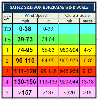
TD: Tropical Depression; TS: Tropical Storm
National Weather Service: historic weather data, including temperatures, wind speeds, humidity, rain, wind chill, heat index, pressure, etc.
Burnet: forecast.weather.gov/data/obhistory/KBMQ.html
Llano: https://forecast.weather.gov/data/obhistory/KAQO.html
For weather history at any location with an airport, you can substitute the airport's four digit "K code" just before "html" in the link format. Airport codes are available at: https://airnav.com/airports/get
SKYWARN: weather.gov/skywarn. A volunteer Storm Spotter program with nearly 290,000 trained severe weather spotters. These volunteers help keep their local communities safe by providing timely and accurate reports of severe weather to the National Weather Service. For local training opportunities and resources, contact: Paul Yura, Austin/San Antonio, 830-606-3617, paul.yura@noaa.gov
SEVERE WEATHER REPORTING TO NOAA: Anyone can submit their storm observations (including photos) at Storm Reports, or to the Storm Prediction Center at: spc.noaa.gov, or via email: caewx@noaa.gov, or Facebook or via Twitter using: @NWSSanAntonio and #ewxspotter or Twitter
SEVERE WEATHER REPORTING TO LOCAL 911: Anyone can submit their storm observations by calling 911.
SEVERE WEATHER REPORTING TO TV MEDIA: Anyone can submit their storm observations by phone, text and email to local radio and TV stations listed above. No guarantee as to how your report will be processed. You might get your name in the news as a credit for the submission. Typical are pictures of clouds, lightning, hail, flooding, wind damage, etc. Check their website above for reporting address.
RAINFALL REPORTING TO COMMUNITY COLLABORATIVE RAIN, HAIL & SNOW NETWORK: Anyone can submit their rainfall data to CoCoRAHS, which tracks this for flooding and drought analysis. cocorahs.org
WEATHER UNIVERSITY: kxan.com/fwwu. This First Warning Weather Univiersity is a free, online, public service at KXAN News that teaches the basics of weather. Includes modules on Weather 101, Seasons, Rain & Thunderstorms, Extreme Weather, and Studying Weather.
Stay tuned for more.
Please offer any items you think would be helpful.
(send to webmaster at email address at info@HillCountryPortal.com)
Site designed, maintained & Copyright © by Cofran & Associates, Inc.All rights reserved
See Terms of Use before using this website.Cofran.cominfo@Cofran.com281-300-7177
Click for Hill Country:
» MARKET DAYS
» ALL CALENDARS
» ATTRACTIONS
» ADVENTURES
» MAPS
What's Raised Here,
Stays Here! 100% local!!

5 locations in
Central Texas
September and October.
Corporate sponsorship
& team/individual
registrations now available.
Affordable Pre-paid Emergency Air Transport Service
Click image for details
Protection starts at $65/yr
Donate To


Protect Your Computer Files With![]()
On-Line storage
of your data.
Easy!
Just click
to get started.