Click for Free
Calendar
Event Submission
Click here for your![]()
basic Portal listing!
FIRST CHOICE SHUTTERS
& BLINDS
![]()
Serving South-Central Texas
Quality window treatments
Plantation shutters, blinds, screens, shades
Wood and faux wood available
Made in America
Locally owned & operated:
Tim & Barbara Van Tassel
830-201-2151
timgvant@hotmail.com
Johnson City, TX
Call, email or text with questions or to arrange a no-obligation visit and quotation at your place.
Facebook

COFRAN'S PC &
TECHNOLOGY HELP
- - -
Online, Remote
Tech Support &
Call-In Help Desk
Virus? Frustrated?
PC slowed down?
We can tune it up!
Internet, Wi-Fi,
Websites,
Email, Outlook,
Social Media,
Tech Marketing,
Excel, Quickbooks,
Zoom, TeamViewer,
Carbonite
** PC Repairs **
BSEE, MBA, xCPA
Veteran, Tech Officer
281-300-7177
Johnson City
info@cofran.com
www.cofran.com
"The Web Guy"
WEB SITE DESIGN
& MAINTENANCE
Economical
& Effective
281-300-7177
Johnson City, TX
info@cofran.com
cofran.com
"Business Coach"
COST CONTROLS,
EFFICIENCY &
BETTER STRATEGIES
= MORE PROFIT !!
Economical
& Effective
281-300-7177
Johnson City, TX
info@cofran.com
cofran.com
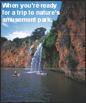
.jpg "Lake Marble Falls")


Cofran's Texas . . .
Hill Country Portal
A Powerful Information Database & Gateway Service for the Texas Hill Country
Area & Lake Profile For:
Highland Lakes Area, Texas
And check out our related Portal focus pages: Parks, Lakes, Rivers, and Outdoors.
We welcome inquiries, comments and submission of updates, additions, corrections & digital photos,
without compensation. Send to Editor at:
editor@HillCountryPortal.com
CITIES IN THE HIGHLAND LAKES AREA: Bertram, Bluffton, Briarcliff, Buchanan Dam, Burnet, Cottonwood Shores, Granite Shoals, Highland Haven, Horseshoe Bay, The Hills, Hudson Bend, Jonestown, Kingsland, Lakeway, Lago Vista, Llano, Marble Falls, Meadowlakes, Spicewood, Sunrise Beach, Tow, Sunrise Beach, Volente
COUNTIES IN THE HIGHLAND LAKES AREA: Burnet, Llano, Travis
CHAMBER, TOURISM & ECONOMIC DEVELOPMENT IN THE HIGHLAND LAKES AREA: See Portal profile pages for each city and county, plus:
LAKE BUCHANAN/INKS LAKE CHAMBER OF COMMERCE:
512-793-2803
POB 282, Buchanan Dam, TX 78609
Web: buchanan-inks.org; E-mail: info@buchanan-inks.com
LAKE TRAVIS CHAMBER OF COMMERCE:
Ofc: 512-263-5833, 877-263-0073
1415 RR-620 S, Ste 202, Austin, TX 78734
Web: laketravischamber.com;
Email: laura@laketravischamber.com
Serves: Bee Cave, Briarcliff, The Hills, Hudson Bend, Lakeway and Spicewood
MEDIA REGARDING HIGHLAND LAKES AREA:
HIGHLAND LAKES: highlandlakes.com
ESCAPE TO THE LAKES & HILLS: lakesandhills.com
LAKES & HILLS: lakesandhillsadventures.com; lakesandhillsvacations.com
THE HIGHLANDER NEWS: highlandernews.com
LAKE COUNTRY LIFE: lakecountrylife.com
HIGHLAND LAKES LIFE: thepicayunetv.com
101 FUN THINGS TO DO IN THE HIGHLAND LAKES: thepicayunetv.com
HIGHLAND LAKES BUSINESS JOURNAL (monthly publication): thepicayunetv.com
RIVER CITIES DAILY TRIBUNE: thepicayunetv.com
KEY WEB RESOURCES FOR HIGHLAND LAKES AREA:
COLORADO RIVER ALLIANCE: 3625 Lake Austin Blvd, Austin, TX 78703. coloradoriver.org. Champions the long-term vitality of the Texas Colorado River through education and engagement. A healthy, flowing river is imperative to the long-term well-being of our community and our state. With programs that reach over 14,000 students and community members annually, we educate Texans young and old about the Colorado River – how it supports us and why, in turn, we must ensure its future. contact@coloradoriver.org
LOWER COLORADO RIVER AUTHORITY (LCRA): lcra.org
WATER LEVELS: LCRA River Report; LCRA Lake Report
OTHER PROFILES: Handbook of Texas On-line; Wikipedia; Texas Escapes: Highland Lake Dams
Maps: LCRA; See lake maps below
Note, see Hill Country Information for parks, wineries, wildflowers, etc in this area.
Marinas In This Lake Area: texassailor.com/marinas.htm
BOAT LAUNCH RAMPS IN THIS AREA: texassailor.com/ramps.htm
PARKS IN THE HIGHLAND LAKES AREA:
There are many Lower Colorado River Authority (LCRA) and state parks in the region that are profiled at Parks
COLORADO RIVER (IN TEXAS): Profiles: Handbook of Texas On-line; Wikipedia
LAKE BUCHANAN:

Dam: Buchanan (LCRA 1939), the largest multi-arch dam in the world
Coordinates: 30° 45.11' N, 98° 25.12' W
Map: Google
Counties: Burnet, Llano
Cities: Buchanan Dam, Bluffton, Tow
Length of dam: 10,988 ft (2.08 miles)
Height of dam: 145.5 ft
Thickness of dam: 215.10 ft (base), 34 ft (top)
Generating Capacity: 37,500 Kilowatts
Lake level (full): 1,020 ft above sea level
Reservoir Capacity: 992,475 acre-ft of water
Lake size: 23,060 acres (36 square miles)
Surface area: 22,333 acres
Max. depth: 132 ft (40 m)
Surface elevation: 1,020 ft
Inflows: Colorado River; Outflows: Colorado River
Facilities: Buchanan Dam Museum & Visitor Center: 512-793-2803. TX-29 W, Buchanan Dam. Dam is open year round. Visitor Center open seasonally. Free Admission. Daily 9a-5p (closed holidays). Map
Parks (See Parks): Canyon of the Eagles, Black Rock LCRA, Cedar Point LCRA
Public Boat Ramps On Lake Buchanan:
- Burnet County Park: Free; NE side of Lake Buchanan. Map
- Llano County Park: Free; SW side of Lake Buchanan. Map
Chamber: Lake Buchanan/Inks Lake Chamber of Commerce:
POB 282, Buchanan Dam, TX 78609, 512-793-2803; Fax: 512-793-2112
Web: buchanan-inks.org, E-mail: info@buchanan-inks.com
Tourism: Lake Buchanan Visitor's Guide: lake-buchanan.net
Special Activity: "Vanishing Texas River Cruise" at N end of lake. Boat docks at Canyon of the Eagles Park. Boat tour of spectacular wilderness along the Colorado River that feeds into the lake. 800-474-8374; vtrc.com
Lake Buchanan Conservation Corporation: 512-470-1138; POB 217; 15675 TX-29, Buchanan Dam, TX. 78609. lakebuchanancc.org
Portal Web Cam Gallery: Buchanan Dam
INKS LAKE:

Dam: Inks (LCRA 1938)
Coordinates: 30° 43.86' N, 98° 23.08' W
Map: Google
Counties: Llano
Cities: Nearby: Buchanan Dam, Burnet, Kingsland
Length of dam: 1,547.5 ft (.3 miles)
Height of dam: 96.5 ft
Thickness of dam: 75.1 ft (base), 6.5 ft (top)
Generating Capacity: 37,500 Kilowatts
Lake level (full): 888 ft above sea level
Max. depth: 60 ft
Surface elevation: 888 ft
Reservoir Capacity: 992,475 acre-ft. of water
Lake size: 802 acres
Inflows: Colorado River; Outflows: Colorado River
Parks (See Parks): Inks Lake State Park
Profiles: Handbook of Texas On-line; Wikipedia; LCRA, TPWD
Chamber: Lake Buchanan/Inks Lake Chamber of Commerce:
PO Box 282, Buchanan Dam, TX 78609, 512-793-2803; Fax: 512-793-2112
Web: buchanan-inks.org, E-mail: info@buchanan-inks.com
Portal Photo Gallery: Inks Lake State Park
LAKE LBJ:

Dam: Wirtz (LCRA 1950), constant level lake
Coordinates: 30° 39.31' N, 98° 26.04' W
Map: Google
Counties: Burnet
Cities: Cottonwood Shores, Granite Shoals, Highland Haven, Horseshoe Bay, Sunrise Beach Village, Near: Kingsland, Marble Falls
Surface area: 6,534 acres
Max. depth: 90 ft
Surface elevation: 825 ft
Inflows: Colorado River and Llano River; Outflows: Colorado River
Parks: Castlebriar Park; LCRA's Nightengale Archaeological Center at Kingsland; remainder of surrounding land is private
Profiles: Handbook of Texas On-line; Wikipedia; LCRA, TPWD
Tourism: Lake LBJ Visitor's Guide: lake-lbj.com
History: Originally named Lake Granite Shoals for the natural granite outcroppings that formed parts of the lake's shorelines, Lake LBJ was renamed in 1965 to honor the 36th President of the United States. It was created by the completion of Alvin Wirtz Dam in 1951, with nearly sixty miles of shoreline. The lake remains virtually constant at about 825 feet above msl.
LAKE MARBLE FALLS:

Dam: Max Starcke (LCRA 1951)
Coordinates: 30° 33.40' N, 98° 15.38' W
Map: Google
Counties: Burnet
Cities: Cottonwood Shores, Marble Falls, Meadowlakes
Surface area: 611 acres
Max. depth: 60 ft
Surface elevation: 738 ft
Inflows: Colorado River; Outflows: Colorado River
Parks: Most of lake border area is privately owned; there are no public parks
Profiles: Handbook of Texas On-line;
Wikipedia; LCRA; TPWD
LAKE TRAVIS:

Dam: Mansfield (LCRA 1942)
Coordinates: 30° 26.4' N, 98° 1.2' W
Map: Google
Counties: Travis
Cities: Briarcliff, The Hills, Hudson Bend, Jonestown, Lakeway, Lago Vista, Point Venture; Spicewood, Volente
Surface area: 18,930 acres
Max. depth: 210 ft max, 62 average
Water volume: 1,130,000 acre-ft
Shore length: 270 mi
Length: 64 mi, Width: 4 mi at widest point
Surface elevation: 681 ft
Inflows: Colorado River; Outflows: Colorado River
Lake Travis Water Temperature Weather Station: arlut.utexas.edu/omg/weather.html
Lake Travis Usage: Flood control, drinking water, recreation, hydroelectric power
Lake Travis Parks (See Parks): Pace Bend, Arkansas Bend, Mansfield Dam, McGreggor Park/Hippie Hollow, Bob Wentz, Cypress Creek, Malberger, Sandy Creek, Jones Brothers, Laura Reed, Dave Reed
Lake Travis Profiles: Handbook of Texas On-line; Wikipedia; LCRA; TPWD; LakeTravis.com; LakeTravisGuide.com; HighlandLakes.net/LakeTravis
Portal Web Cam Gallery for Lake Travis: Lake Travis-Oasis; Lake Travis-Steiner
BUT JUST OUTSIDE THE HILL COUNTRY
LAKE AUSTIN:
Dam: Tom Miller
Coordinates: 30° 17.66' N, 97° 47.18' W
Counties: Travis
Cities: Austin
Map: Google
Surface area: 1,599 acres
Max. depth: 75 ft
Surface elevation: 492 ft
Inflows: Colorado River; Outflows: Colorado River
Parks:
Profiles: Handbook of Texas On-line; Wikipedia; LCRA; TPWD
LADY BIRD LAKE (FORMERLY TOWN LAKE):
Dam: Longhorn
Coordinates: 30° 15.9' N, 97° 45.5' W
Counties: Travis
Cities: Austin
Map: Google
Lake size: 468 acres
Max. depth: 18 ft
Surface elevation: 428 ft
Inflows: Colorado River; Outflows: Colorado River
Parks: Zilker (City of Austin)
Profiles: Handbook of Texas On-line; Wikipedia; LCRA; TPWD; Texas Outside
2222 COALITION OF NEIGHBORHOOD ASSOCIATIONS: 2222CONA.org
BULL CREEK FOUNDATION: bullcreek.net. A non-profit organization dedicated to promoting a harmonious balance between nature, recreation, and sustainable economic development within the 32 square mile Bull Creek watershed.
DRAINING LAKE TRAVIS: draininglaketravis.org
HIGHLAND LAKES GROUP/WATER MATTERS: hlgrp.org. HLG opposes the "San Antonio Hose", working to keep Highland Lakes water supplies from being "hijacked" by other cities.
HILL COUNTRY SPECIAL: Maps
PROTECT LAKE TRAVIS: protectlaketravis.org
Site designed, maintained & Copyright © by Cofran & Associates, Inc.All rights reserved
See Terms of Use before using this website.Cofran.cominfo@Cofran.com281-300-7177
Click for Hill Country:
» MARKET DAYS
» ALL CALENDARS
» ATTRACTIONS
» ADVENTURES
» MAPS
Click To Visit Burnet County
Just an hour's drive from
Austin or San Antonio
in the beautiful
Texas Hill Country


Affordable Pre-paid Emergency Air Transport Service

Click image for details
Protection starts at $65/yr

Protect Your Computer Files With![]()
On-Line storage
of your data.
Easy!
Just click
to get started.