Click for Free
Calendar
Event Submission
Click here for your![]()
basic Portal listing!
FIRST CHOICE SHUTTERS
& BLINDS
![]()
Serving South-Central Texas
Quality window treatments
Plantation shutters, blinds, screens, shades
Wood and faux wood available
Made in America
Locally owned & operated:
Tim & Barbara Van Tassel
830-201-2151
timgvant@hotmail.com
Johnson City, TX
Call, email or text with questions or to arrange a no-obligation visit and quotation at your place.
Facebook

Support the

LBJ National
Historical Park
COFRAN'S PC &
TECHNOLOGY HELP
- - -
Online, Remote
Tech Support &
Call-In Help Desk
Virus? Frustrated?
PC slowed down?
We can tune it up!
Internet, Wi-Fi,
Websites,
Email, Outlook,
Social Media,
Tech Marketing,
Excel, Quickbooks,
Zoom, TeamViewer,
Carbonite
** PC Repairs **
BSEE, MBA, xCPA
Veteran, Tech Officer
281-300-7177
Johnson City
GeorgeCofran@Gmail.com
www.cofran.com
"The Web Guy"
WEB SITE DESIGN
& MAINTENANCE
Economical
& Effective
281-300-7177
Johnson City, TX
GeorgeCofran@Gmail.com
cofran.com
"Business Coach"
COST CONTROLS,
EFFICIENCY &
BETTER STRATEGIES
= MORE PROFIT !!
Economical
& Effective
281-300-7177
Johnson City, TX
GeorgeCofran@Gmail.com
cofran.com

Cofran's Texas . . .
Hill Country Portal
A Powerful Information Database & Gateway Service for the Texas Hill Country
Focus Topic Profile For:
HILL COUNTRY PARKS, LAKES & RIVERS
 This resource page focuses on national parks, state parks, LCRA parks, large county parks, city parks, privately owned parks, and other major parks, natural areas, preserves, lakes, rivers, fish hatcheries, caves, forts and related resources in the Texas Hill Country. We are indeed blessed with an unusual wealth of natural resources in our beautiful Texas Hill Country. Enjoy and preserve them.
See clickable city and county Portal profiles for information about the area where the parks are located, and for smaller municipal, county and privately owned parks in the Texas Hill Country.
Also check out all the places where you can go swimming in a natural setting, as opposed to public, man-made swimming pools. Naturally, they are all related to rivers and streams as the source of and catchment for water. Many are accessible via the public parks on this pagge. See our list of them at Swimming Holes.
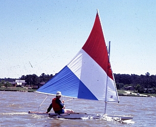
If you are in to horses, check out our focus page: Horses & Riding in the Hill Country, and water recreation at Tubing & Paddling.
We welcome inquiries, comments and submission of updates, additions, corrections & digital photos,
without compensation. Send to Editor at:
editor@HillCountryPortal.com
- National Park Service Parks in the Hill Country
- US Army Corps Of Engineers Parks in the Hill Country
- US Fish & Wildlife Service Parks in the Hill Country
- Texas State Parks & SNA's
- Lower Colorado River Authority (LCRA) Parks
- Local Government Public Parks
- Privately Owned, Commercial Parks & Nature Attractions
- Lakes
- Rivers
- Fish Hatcheries
- Bats & Bat Caves
- Historic Military Forts
- Resources
Also see:
NPS: Park Locator and Western National Parks Association: Parks

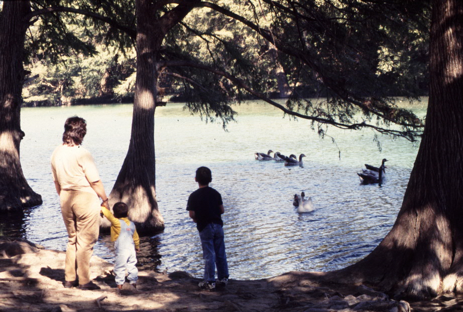
LYNDON B. JOHNSON
NATIONAL HISTORICAL PARK
- JOHNSON CITY:
This park tells the story of our 36th President beginning with his ancestors until his final resting place on his beloved LBJ Ranch in nearby Stonewall. This entire "circle of life" gives the visitor a unique perspective into one of America's most noteworthy citizens by providing the most complete picture of an American president. Facilities: NPS-JC headquarters, video viewing, artifacts, gift/book store, LBJ's Boyhood Home, the "Johnson Settlement" (historic buildings from LBJ's forefather's period), nature trails, horses and longhorns, a meeting/conference event center with full amenities. Guided, unguided and group tours are available.
The restored Withers & Spauldings building (Visitor Center, with LBJ memorabilia) is in the format of a general store exhibit area spanning several time periods from 1915-1973 and is located on the corner of Main Street (U.S. Highway 290) and Nugent Avenue in Johnson City.
Location: National Park Service: In Blanco County, at 100 Ladybird Lane at Ave F, Johnson City; Information: 830-868-7128; nps.gov/lyjo; Friends of LBJ National Historical Park; Facebook
Click Map (requires Adobe Reader).
Portal Photo Gallery: LBJ National Historical Park - Johnson City
LYNDON B. JOHNSON
NATIONAL HISTORICAL PARK - STONEWALL:
 Guided and unguided tours of this park facility, the birthplace of LBJ and location of the "Texas White House" at the LBJ Ranch (open to the public). LBJ National and State Parks celebrate the holidays with special book signing events and the annual tree lighting and LBJ Ranch Christmas lights tour. The State of Texas manages a Visitor Center near Stonewall where visitor can obtain a free driving permit to the LBJ Ranch (managed by the National Park Service). This national park is on the N side of the Pedernales River and directly across from the LBJ State Historical Park on the S side (see below in state parks). The rural Junction School House is also here and tours can be arranged.
Location: National Park Service: In Gillespie County, 14 mi W of Johnson City, at 1048 TX-49 (off US-290), Stonewall. See Johnson City contact and web/email information above.
Portal Photo Gallery: LBJ National Historical Park - Stonewall
NPS/TPWD Video: Park Orientation
Texas White House Videos (2022): E1: Home On The Pedernales; E2: Becoming the Texas White House; E3: The Lady Bird Years; E4: All The World Is Welcome Here; E5: Historic Preservation: Past, Present, and Future
Also see:
Corps: Homepage and Corps: Parks & Lakes
Portal Photo Gallery: Canyon Lake Parks
 CANYON PARK:
On N shore of Canyon Lake near Hancock. Features: 150 campsites, 2 overnight shelters and 1 day use shelter.
CANYON PARK:
On N shore of Canyon Lake near Hancock. Features: 150 campsites, 2 overnight shelters and 1 day use shelter.
Location: In Comal County at Canyon Lake. From IH-35 take Exit 191 N of New Braunfels. Drive W on FM-306 20 mi, turn L on Canyon Park Road or from US-281 turn E on FM-306, travel E 12 miles, turn R on Canyon Park Road. Coordinates: N 29° 53.872', W 098° 14.005'
CANYON BEACH PARK: On the N shore of Canyon Lake near Hancock.
Location: From IH-35, take Exit 191 N of New Braunfels. Drive W on FM-306 going 18 mi, turn L on Canyon Park Road. Or from US-281 turn E on FM-306, travel 12 mi; turn R on Canyon Park Rd. Canyon Beach is located about 1 mi on L of Canyon Park Road. Canyon Swim Beach is located to the L before entering Canyon Park. Coordinates: N 29° 54.339', W 098° 13.526'
COMAL PARK: On the S shore of Canyon Lake near Startzville. Open daily Mar 1-Sep 30 from 7a to sunset. Facilities: 2 double-lane boat ramps, 65 shady picnic sites, a large swim beach, children's playground, and horseshoe pits.
Location: In Comal County at Canyon Lake. From IH-35, take FM-306 Exit 191 just N of New Braunfels; travel W on FM-306 for 14 mi to FM-2673 and turn L. Continue W on FM 2673 for 8 mi to the Dairy Queen in Startzville and turn R on Canyon Bend Street. Follow signs to park for additional 2 mi. Or from US-281 take TX-46 E past Smithson Valley High School and turn L on FM 3159. Continue on FM 3159 for 6.7 mi, then turn L at the traffic light on FM 2673 in Startzville. Continue on FM 2673 for 1 mi. Turn R at the Dairy Queen on Canyon Bend Street. Follow signs to the park for an additional 2 mi. Coordinates: N 29° 51.760', W 098° 15.143'
CRANES MILL PARK: On the SW shore of Canyon Lake off FM 2673, just past village of Startzville. Open year-round, 7a to 10p daily. Facilities: 46 campsites with tables cookers only (no RV hookups).
Location: In Comal County at Canyon Lake. From IH-35 take Canyon Lake exit W on FM-306; about 14 mi. Turn L on FM-2673 just after Guadalupe River crossing. Cranes Mill Park is located at westernmost end of FM-2673 and South Cranes Mill Road. Coordinates: N 29° 53.340', W 098° 17.561'
GUADALUPE PARK: Located below Canyon Dam along the first mile of the Guadalupe River. It's minimal developments include fishing access from 2 river trails. Public fishing pier on L bank below Guadalupe-Blanco River Authority (GBRA) hydropower plant. This stretch of river is very popular as the State's premier trout fishing stream. The Guadalupe River is the Southernmost sustainable trout fishery in the nation. No camping or picnic facilities available. A restroom facility is located at nearby Overlook Park near the southern end of Canyon Dam. Overlook Park closes at sunset daily. No fees.
Location: In Comal County at Canyon Lake.
NORTH PARK: Located off FM 306 near the Canyon Lake dam. Open from 7a to 10p. Facilities: 19 campsites (no RV hookups), vault toilets, no showers, no boat ramp. This is a popular scuba diving area.
Location: In Comal County; Canyon Lake. From IH-35 take FM-306 Exit 191 located just W of New Braunfels, travel W on FM-306 for 18.5 mi, or from US-281 take FM-306 E 16.5 mi. Coordinates: N 29° 52.507', W 098° 12.074'
OVERLOOK PARK: On a hilltop near the S end of Canyon Dam. Open daily from 7a until sunset and is the access to the Corps of Engineers headquarters at Canyon Lake Visitor office. Offers a scenic view to the lake and dam. Access to Verada Real walking trail across the Dam. Restrooms and visitor parking are available. There are no camping or picnic facilities. No fees.
Location: In Comal County at Canyon Lake. From FM-306 follow South Access Road to C.O.E. Road and turn R and proceed up the hill. Or, from FM-2673 at Sattler, go NW on South Access Road for 2 mi, turn L on C.O.E. Road and proceed up the hill. Coordinates: N 29° 51.663', W 098° 11.891'
POTTER'S CREEK PARK: On NW side of Canyon Lake. Features: 114 campsites, 1 group shelter, 5 multi-family campsites (for 2-3 RV's), and 7 screened shelters. Additional amenities include restrooms with showers, 2 dump stations, 2 boat ramps, and a beach area. All sites have water and electric hookups, a covered picnic table, stand up grill, and fire ring. Activities include bird watching, hiking, biking, fishing, swimming, wildlife viewing and interpretive programs. Open year round. Reservations must be made at least 4 days in advance.
Location: In Comal County at Canyon Lake, at 3145 Potter's Creek Rd near intersection of FM-306 and Hwy-484 (Fischer Rd). Turn S on Potter's Creek Road and continue 2 mi to park entrance. Canyon Lake, TX 78133; 830-964-3341.
Coordinates: N 29° 54.411', W 098° 15.821'
reserveamerica.com/campgroundDetails.do?subTabIndex=0&&contractCode=nrso&parkCode=potc
swf67.swf-wc.usace.army.mil/canyon
corpslakes.usace.army.mil/visitors/projects.cfm?Id=M202590
Back To >> TOP OF PAGE & MAIN INDEX or BEGINNING OF DIRECTORY LISTINGS THIS PAGE

BALCONES CANYONLANDS NATIONAL WILDLIFE REFUGE: 512-339-9432; 24518 FM-1431 E. fws.gov/refuge/balcones-canyonlands. Maintained by US Fish & Wildlife Service. A huge (25,00 ac) home to many native Texas wildlife and plants. Established to protect the nesting grounds of the black-capped vireo and the endangered golden-cheeked warbler. This refuge also helps protect water quality in central Texas and lies just N of Lake Travis, the drinking water reservoir for the Austin metro area. Observation decks. Popular birding, wildlife and hiking (10 miles of foot trails) refuge. Frequent public programs & activities. Open daylight hours. Free admission. Located E of Marble Falls, S of Bertram, SW of Liberty Hill, and NW of Lago Vista. Map. Entrance at Cow Creek Rd, Lago Vista, TX 78645. HQ located off FM-1431.
IN THE HILL COUNTRY

Also see: TPWD Park Locator
TPWD General Information: 800-792-1112; Reservations: 512-389-8900
Also see: TPWD Fresh Water Lakes
ADMIRAL NIMITZ STATE HISTORIC SITE & NATIONAL MUSEUM OF THE PACIFIC WAR:
The only institution in the continental United States dedicated exclusively to the story of Fleet Admiral Chester W. Nimitz and World War II in the Pacific Theater, located on a 9-acre site in Fredericksburg, Texas. The complex includes The National Museum of the Pacific War-George Bush Gallery, the Admiral Nimitz Museum, the Japanese Garden of Peace, the Pacific Combat Zone, the Plaza of the Presidents, the Surface Warfare Plaza, the Memorial Wall, the Veterans Walk of Honor and the Center for Pacific War Studies. In addition to nearly 45,000 sf of indoor exhibit space, the museum boasts an impressive display of Allied and Japanese aircraft, tanks, guns and other large artifacts made famous during the Pacific War campaigns.
Location: In Gillespie County, at 328 E Main St, Fredericksburg. At corner of Main St and US-87; 830-997-4379; nimitz-museum.org;
thc.state.tx.us/museums/musnimitz.shtml
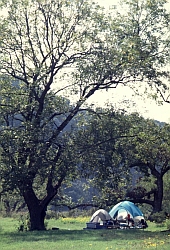
 BLANCO STATE PARK: This 105-acre park has camping, swimming, hiking, camping, fishing, swimming, pedal boats and rentals, children's play area, rest rooms and showers. Opened in 1934. Elevation 1350 ft. Facilities include
restrooms with and without showers; campsites with water and electricity; campsites with water, electricity, and sewer; screened shelters; picnic areas, dump station; playgrounds; a store; a 3/4-mile nature trail. Open year around.
BLANCO STATE PARK: This 105-acre park has camping, swimming, hiking, camping, fishing, swimming, pedal boats and rentals, children's play area, rest rooms and showers. Opened in 1934. Elevation 1350 ft. Facilities include
restrooms with and without showers; campsites with water and electricity; campsites with water, electricity, and sewer; screened shelters; picnic areas, dump station; playgrounds; a store; a 3/4-mile nature trail. Open year around.
Location: In Blanco County, at 101 Park Road 23, Blanco; Only 4 blocks S of the town square, turn on Park Road 23; 830-833-4333; tpwd.texas.gov/state-parks/blanco/
Portal Photo Gallery: Blanco State Park
 COLORADO BEND STATE PARK:
5,328 acres above Lake Buchanan, at 1025 ft elevation, opened in 1987. Offers a wide spectrum of outdoor recreational opportunities including fishing, boating, hiking, mountain biking, guided nature and caving tours, bird watching, mineral study and photography. Among the park's "specialty items," are its crystal-clear creeks dammed along their length with striking growths of travertine, a mineral precipitate from calcium-carbonate rich waters.
COLORADO BEND STATE PARK:
5,328 acres above Lake Buchanan, at 1025 ft elevation, opened in 1987. Offers a wide spectrum of outdoor recreational opportunities including fishing, boating, hiking, mountain biking, guided nature and caving tours, bird watching, mineral study and photography. Among the park's "specialty items," are its crystal-clear creeks dammed along their length with striking growths of travertine, a mineral precipitate from calcium-carbonate rich waters. Primitive tent camping and "drive-in" camping. Park has 16 mi of hiking trails and 14 mi of mountain bike trails. When Lake Buchanan is near normal levels, the river is navigable from the park's boat ramp all the way to the lake (10 mi). This is a trip on slow moving water through the beautiful canyon lands of the Colorado. Also available: guided, walking, wild-cave tours and self-guided crawling cave explorations.
The Park offers a diversity of activities everyday, including:
- Crawling Cave Tours: Colorado Bend is known for having caves! Cave tours offered, each tour can accommodate up to 10 people. Call to reserve a spot. Due to hazards in the caves, such as low oxygen levels and poisonous gases and the fact that the caves are a non-renewable natural resource, all caves in the park are closed except through tour or special permit.
- Hike to Gorman Spring and Gorman Falls: See where the falls begin with a hike to Gorman Spring. Then hike down to see Gorman Falls, one of the most photographed places in Texas! Saturdays. Accessible by a day-use hiking trail, a 4 mi round trip.
- Hike Spicewood Springs Trail: This is a very scenic hiking trail with small waterfalls, travertine, and several creek crossings.
- Mountain Bike up to 20 Miles of Trail! The trail building project is in its 4th year! Bring your bike (or your feet!) and check out what has been built.
- Fishing: Colorado Bend is on the Colorado River and fishing is a favorite pastime for visitors.
- Kayaking: Rent a kayak for a donation and check out the views from the river!
Friends of Colorado Bend State Park: friendsofcoloradobend.com
Portal Photo Gallery: Colorado Bend State Park
DEVIL'S SINKHOLE STATE NATURAL AREA: A natural cave descending 150 feet in a sheer drop. A wildlife preserve and home to a large Mexican free-tailed bat cave. Texas' largest one-chamber cave and 4th deepest cave.
Location: In Edwards county, 7 mi N of Rocksprings. Call 830-683-2287 for tours (May-Oct) that begin at Rocksprings Visitors Center. Other available tours include birding, nature walks, motorcycle and day tours. See: tpwd.texas.gov/state-parks/devils-sinkhole, and Bats
Portal Photo Gallery: Devils Sinkhole SNA
 ENCHANTED ROCK STATE NATURAL AREA:
Located on the SE margin of the large Enchanted Rock Batholith, the granite exposed is one of the Town Mountain Granite suite and is of Precambrian age (6 million years old). Part of the Llano Uplift. There are several large exfoliation domes and castle tops in the park. The largest top (Enchanted Rock itself) rises 122 m. above the surrounding landscape. This is the best place to look at granite in Texas. 1644 acres, opened 1984.
ENCHANTED ROCK STATE NATURAL AREA:
Located on the SE margin of the large Enchanted Rock Batholith, the granite exposed is one of the Town Mountain Granite suite and is of Precambrian age (6 million years old). Part of the Llano Uplift. There are several large exfoliation domes and castle tops in the park. The largest top (Enchanted Rock itself) rises 122 m. above the surrounding landscape. This is the best place to look at granite in Texas. 1644 acres, opened 1984.The Rock is a huge, pink granite exfoliation dome, that rises 425 feet above ground, 1825 feet above sea level, and covers 640 acres. It is one of the largest batholiths (underground rock formation uncovered by erosion) in the United States.
Activities include primitive backpacking, camping, hiking, technical and rock climbing, picnicking, geological study, bird watching, and star gazing (minimal light pollution). No vehicular camping. Facilities include Park Store.
Location: In Gillespie County, on 16710 RR-965, Fredericksburg; 830-685-3636;
enchantedrock.org; tpwd.texas.gov/state-parks/enchanted-rock/
Portal Photo Gallery: Enchanted Rock SNA
UT Photo Gallery: E-rock Virtual Field Trip: uts.cc.utexas.edu/~rmr/E-rock/E-rock.html
Friends Of Enchanted Rock: POB 2602, Fredericksburg, TX 78624. friendsofenchantedrock.com
 GARNER STATE PARK:
1420 acres (10 water acres of the Frio River) of recreational facilities. Many thousands of visitors flock here each year to enjoy its matchless vacation facilities. They swim in the clear waters of the Frio River, scoot its rapids on inner tubes, rent pedal boats, and hike its fascinating nature trails. On long summer evenings, young folks (and the young at heart) meet at the concession building for jukebox dancing every night during the summer season. Nearby is a miniature golf course, which is lighted for nighttime playing. Meals and snacks are served in the concession building, though many families prefer to take advantage of the many camping sites and do their own cooking. Limited number of cabins available for rent. Park offers camping, hiking, nature study, picnicking, canoeing, fishing, swimming in the Frio River (unsupervised), seasonal miniature golf, paddle boat and kayak rentals (mid-March through Labor Day weekend), bike riding (surfaced).
GARNER STATE PARK:
1420 acres (10 water acres of the Frio River) of recreational facilities. Many thousands of visitors flock here each year to enjoy its matchless vacation facilities. They swim in the clear waters of the Frio River, scoot its rapids on inner tubes, rent pedal boats, and hike its fascinating nature trails. On long summer evenings, young folks (and the young at heart) meet at the concession building for jukebox dancing every night during the summer season. Nearby is a miniature golf course, which is lighted for nighttime playing. Meals and snacks are served in the concession building, though many families prefer to take advantage of the many camping sites and do their own cooking. Limited number of cabins available for rent. Park offers camping, hiking, nature study, picnicking, canoeing, fishing, swimming in the Frio River (unsupervised), seasonal miniature golf, paddle boat and kayak rentals (mid-March through Labor Day weekend), bike riding (surfaced).
Location: In northern Uvalde County at 234 RR-1050, Concan; 31 mi N of the town of Uvalde, 9 mi S of Leakey, 8 mi N of Concan830-232-6132; tpwd.texas.gov/state-parks/garner
Portal Photo Gallery: Garner State Park
GOVERNMENT CANYON STATE NATURAL AREA: One of the nation's largest urban preserves protecting thousands of acres of karst (recharge zone) for the Edwards Aquifer. 40 miles of trails, stone buildings, and visitor center/park store with exhibit hall and classrooms. Camping, group facilities, picnicking, wildlife viewing, interpretive programs.
Location: On the edge of the Hill Country in far NW Bexar County, S of Boerne, SE of Bandera, near at 12861 Galm Rd, San Antonio. In NW corner of city limits of San Antonio. 3.5 mi NW of Loop 1604 on Culebra Rd, then 1.6 mi N on Galm Rd.
210-688-9055; tpwd.texas.gov/state-parks/government-canyon
 GUADALUPE RIVER STATE PARK:
1,939-acre scenic park is bisected by the beautiful, cypress-edged river that flows over natural rapids in the park. Limestone bluffs and huge bald cypress trees cling to the banks, the focal point of this park. Wildlife includes white-tail deer, coyotes, foxes, and armadillos; juniper thickets offer nesting habitat for rare golden-cheeked warbler. Tent and RV camping, rest rooms, showers, picnic sites, plus fishing, canoeing, swimming, and hiking are available.
GUADALUPE RIVER STATE PARK:
1,939-acre scenic park is bisected by the beautiful, cypress-edged river that flows over natural rapids in the park. Limestone bluffs and huge bald cypress trees cling to the banks, the focal point of this park. Wildlife includes white-tail deer, coyotes, foxes, and armadillos; juniper thickets offer nesting habitat for rare golden-cheeked warbler. Tent and RV camping, rest rooms, showers, picnic sites, plus fishing, canoeing, swimming, and hiking are available.
This park has 4 mi of river frontage and is located in the middle of a 9 mi stretch of the Guadalupe River. Activities include canoeing, fishing, swimming, tubing, picnicking, hiking, camping, bird watching and nature study. Park has a 5 mi equestrian and mountain biking trail. No equestrian camping. Adjacent to Honey Creek State Natural Area.
Location: In Comal and Kendall counties, 30 mi N of downtown San Antonio and 13 mi E of Boerne, off TX-46, on 3350 Park Rd 31, near Bulverde, in Spring Branch;
830-438-2656; tpwd.texas.gov/state-parks/guadalupe-river
Portal Photo Gallery: Guadalupe State Park
HILL COUNTRY STATE NATURAL AREA: Opened in 1983, this remains as an undeveloped and secluded retreat. Approximately 40 mi of multi-use trails wind up grassy valleys, cross spring-fed streams, and climb steep limestone hills. Backcountry setting for activities such as primitive camping, backpacking, mountain biking, hiking, horseback riding, flora and fauna observation, and limited swimming (3 designated swimming areas are on West Verde Creek). Moderate fishing opportunities. Various adjacent ranches offer horse rentals, tours and other accommodations through this Natural Area. For information call Bandera County Convention and Visitors bureau: 800-364-3883; banderacowboycapital.com
See TPWD Video on horseback riding & camping at Hill Country State Natural Area:
Location: In Bandera County, at 10600 Bandera Creek Rd, Bandera;
830-796-4413; tpwd.texas.gov/state-parks/hill-country
 HONEY CREEK STATE NATURAL AREA:
2294 acres, opened 1985. Entry into Honey Creek is for guided tours only. The diverse geology, flora, and fauna make Honey Creek a special place for all visitors using 2 mi of nature/interpretive trails. Saturday morning walking tour begins at 9a. Reservations required. No facilities except for trails.
HONEY CREEK STATE NATURAL AREA:
2294 acres, opened 1985. Entry into Honey Creek is for guided tours only. The diverse geology, flora, and fauna make Honey Creek a special place for all visitors using 2 mi of nature/interpretive trails. Saturday morning walking tour begins at 9a. Reservations required. No facilities except for trails.
Location: c/o Guadalupe River State Park, 3350 Park Rd 31, Spring Branch.
830-438-2656; tpwd.texas.gov/state-parks/honey-creek
Friends Group: honeycreekfriends.com
Portal Photo Gallery: Honey Creek SNA
 INKS LAKE STATE PARK:
A 1,200 acre panorama of cedar and oak woodlands, wildflowers, and pink granite outcroppings. The park borders Inks Lake, and recreational opportunities include swimming, boating, canoeing, water skiing, scuba diving, sailing, and fishing. Deer, turkey, quail, numerous songbirds, and other species of wildlife are abundant here.
INKS LAKE STATE PARK:
A 1,200 acre panorama of cedar and oak woodlands, wildflowers, and pink granite outcroppings. The park borders Inks Lake, and recreational opportunities include swimming, boating, canoeing, water skiing, scuba diving, sailing, and fishing. Deer, turkey, quail, numerous songbirds, and other species of wildlife are abundant here.RV camping, tent campsites and shelters accommodate up to 8 persons, with a combination of motor vehicles and trailers not to exceed two. Picnic table, BBQ grill and restrooms with hot showers are nearby. There is no lifeguard on duty for swimming. 2 fishing piers, 2 fish cleaning shelters, a 2-lane boat ramp, wi-fi internet access, playground and concession store offers groceries, picnic supplies, canoe, boat, and paddleboat rentals. Constant level lake, elevation 900 ft.
Location: In Burnet County, at 3630 Park Road 4 West, Lake Buchanan Area; 9 mi W of Burnet on TX-29, to 3630 Park Road 4. Go S 3 mi to the park HQ. Locally, the area is called Hoover’s Valley.
512-793-2223; tpwd.texas.gov/state-parks/inks-lake; TPWD Inks Lake Fishing Profile; See Portal's Highland Lakes detailed profile for Inks Lake
Portal Photo Gallery: Inks Lake State Park
 LONGHORN CAVERN STATE PARK:
This huge cave once was a favorite roosting cave for bats. Now, there are only about a dozen Eastern Pipistrelle bats in Longhorn Cavern. They do not hang out together, they are loners. Cave staff now report they get to see one every now and then during the winter months when the bats are hibernating. For more information on the bats that live inside Longhorn Cavern, visit their Gift Shop and request a book named "Hey! I've Got Feelings Too!". Longhorn Cavern State Park is a 646 acre scenic park, featuring Longhorn Cavern, formed in prehistoric times by water flow. Activities include hiking; a 1.5 hour cave tour covering 1.25 miles of caves; and a geology program. Facilities include a gift shop, a full service deli and snack counter, gift shop, a picnic area, and 2 mi of hiking trails. Open for day-use only. Elevation: 779 to 1585 ft. Admission fee for cave tours.
LONGHORN CAVERN STATE PARK:
This huge cave once was a favorite roosting cave for bats. Now, there are only about a dozen Eastern Pipistrelle bats in Longhorn Cavern. They do not hang out together, they are loners. Cave staff now report they get to see one every now and then during the winter months when the bats are hibernating. For more information on the bats that live inside Longhorn Cavern, visit their Gift Shop and request a book named "Hey! I've Got Feelings Too!". Longhorn Cavern State Park is a 646 acre scenic park, featuring Longhorn Cavern, formed in prehistoric times by water flow. Activities include hiking; a 1.5 hour cave tour covering 1.25 miles of caves; and a geology program. Facilities include a gift shop, a full service deli and snack counter, gift shop, a picnic area, and 2 mi of hiking trails. Open for day-use only. Elevation: 779 to 1585 ft. Admission fee for cave tours.
Location: In Burnet County, in Burnet. 6 mi W of US-281, on Park Road 4.
1-877-441-2283, 830-598-2283; visitlonghorncavern.com, tpwd.state.tx.us/spdest/findadest/parks/longhorn_cavern
By reservation, PRIVATELY GUIDED TOUR OF LONGHORN CAVERN: 512-809-8057; Park Rd 4, near Kingsland, Lake Buchanan Area & Burnet. Choice A: For groups, min $200 fee, 4.5 hour program; Choice B: 2 hour program, standard individual ticket price plus gratuity.
Portal Photo Gallery: Longhorn Cavern SP
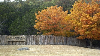 LOST MAPLES STATE NATURAL AREA:
While they aren't actually "lost," the bigtooth maples for which the park is named are selective in their habitat. Because of their shallow roots, the trees are susceptible to damage by soil compaction and visitors are cautioned to stay on prescribed paths to ensure continued vigor of the maple stands. Fall color is usually at its peak in early November.
LOST MAPLES STATE NATURAL AREA:
While they aren't actually "lost," the bigtooth maples for which the park is named are selective in their habitat. Because of their shallow roots, the trees are susceptible to damage by soil compaction and visitors are cautioned to stay on prescribed paths to ensure continued vigor of the maple stands. Fall color is usually at its peak in early November.
Visitors enjoy picnicking, camping, backpacking, sightseeing, hiking, photography, birdwatching, fishing, swimming, and nature study. Many natural hazards exist due to the steep/rugged errain. Facilities include restrooms with showers, picnic sites, primitive camping areas, a comfort station, campsites with water and electricity, and a trailer dump station, Park Store, 1/2-mi of nature trails, and 11 mi of hiking trails.
This Area covers 2174 scenic acres in Bandera and Real Counties, N of Vanderpool on the Sabinal River. Elevation ranges from 1800 to 2250 feet. Opened to the public in 1979. The annual visitation is approximately 200,000 visitors.
Location: In Bandera County, 4 mi N of Vanderpool, at 37221 FM-187; 830-966-3413; tpwd.texas.gov/state-parks/lost-maples
Portal Photo Gallery: Lost Maples SNA
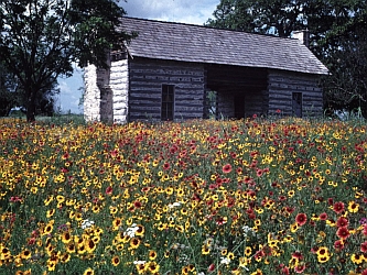 LYNDON B. JOHNSON STATE PARK & HISTORIC SITE:
Located between Fredericksburg and Johnson City in Stonewall, and contains 733 acres. Park honors a native Texan who achieved the nation's highest office. (Note, also see national parks above for the adjacent LBJ National Park).
LYNDON B. JOHNSON STATE PARK & HISTORIC SITE:
Located between Fredericksburg and Johnson City in Stonewall, and contains 733 acres. Park honors a native Texan who achieved the nation's highest office. (Note, also see national parks above for the adjacent LBJ National Park).Open daily from 8a-5p in the summer and offers picnic facilities, swimming pool, tennis courts and nature trails. Wildlife displays include Texas Longhorns, white-tailed deer and buffalo. Historic buildings include two restored dog-run cabins of area pioneers, furnished in frontier style, and the Sauer-Beckmann Farmstead (open daily 8a-4:30p) where rural life of the early 1918 is interpreted by living history demonstrations. Visitors to this day-use park can enjoy historical study, picnicking, nature study, fishing, swimming. The abundant wildlife of the Hill Country is highlighted by enclosures containing buffalo, longhorn, and white-tailed deer. The park is famous for its spring wildflower display. The Visitor Center is the focal point and contains memorabilia from LBJ's presidency and interactive displays about the Land and People that shaped a president. Attached to the Visitors Center is the Behrens Cabin, a 2-room dogtrot cabin built by German immigrant H. C. Behrens during the 1870s.
 The furnishings are typical of such homes in that period. Visitors can further explore the history of these immigrants by viewing the 1860s Danz family log cabin located just W of the Visitor Center. An auditorium in the visitor center complex will accommodate 234 persons for state performances or films. An outdoor amphitheater is used for a variety of programs. A nature trail, including a Hill Country botanical exhibit, winds past wildlife enclosures stocked with bison, white-tailed deer other native wildlife and longhorn cattle.
Location: In Gillespie County, on US-290 just E of Stonewall; 830-644-2420; 830-644-2252; tpwd.state.tx.us/spdest/findadest/parks/lyndon_b_johnson
www.tpwd.state.tx.us/park/lbj/lbj.htm
Portal Photo Gallery: LBJ State Park
OLD TUNNEL STATE PARK (FORMERLY WILDLIFE MANAGEMENT AREA BAT ROOST):
 16 acres and seasonal home to a colony of 1-3 million Mexican Free-tailed bats. Upper viewing area open 7 nights a week, free access. Lower viewing area open May-Oct on Thu-Sun, no reservations, a fee is charged. Group tours. Half-mile hiking/nature trail, picnic tables, and exhibits.
Location: In Kendall County, on Old San Antonio Rd,
11 mi SE of Fredericksburg,
mid-way between US 290 and FM 473 at
Alamo Springs: 866-978-2287
Latitude: 30.101, Longitude: -98.821
TPWD Profile; Reference Article. See Bats
Photo Gallery: Old Tunnel
 PEDERNALES FALLS STATE PARK:
5212 acres located along the banks of scenic Pedernales River and features picturesque waterfalls, abundant animal and bird life, fishing, swimming, tubing, camping, picnicking, hiking, mountain biking and horseback riding. Main attraction is the set of waterfalls carved out of the limestone terrain that can be viewed from a scenic overlook at the north end of the park. In this area, the elevation of the river drops about 50 feet over a distance of 3000 feet, and the cascading falls are formed by the flow of water over the tilted, stair-step effect of layered limestone.
PEDERNALES FALLS STATE PARK:
5212 acres located along the banks of scenic Pedernales River and features picturesque waterfalls, abundant animal and bird life, fishing, swimming, tubing, camping, picnicking, hiking, mountain biking and horseback riding. Main attraction is the set of waterfalls carved out of the limestone terrain that can be viewed from a scenic overlook at the north end of the park. In this area, the elevation of the river drops about 50 feet over a distance of 3000 feet, and the cascading falls are formed by the flow of water over the tilted, stair-step effect of layered limestone.
Location: In Blanco County, 8 mi E of Johnson City on FM-2766 at 2585 Park Road 6026. 830-868-7304; tpwd.texas.gov/state-parks/pedernales-falls; Video
Portal Photo Gallery: Pedernales Falls State Park
SOUTH LLANO RIVER STATE PARK: Cool clear water, shady trees, and abundant wildlife all make this an ideal camping spot. The winding South Llano River forms the northern park boundary with 1.5 miles of river frontage. The 507-acre wooded bottomland is home to the white-tail deer and Rio Grande turkey. Campsites accommodate up to 8 persons each, with a combination of motor vehicles and trailers not to exceed 2; sites have picnic table and BBQ grill. In addition to primitive campsites there are walk-in campsites with picnic tables and fire rings, campsites with water and electricity which include back-in parking; and a restroom with hot showers nearby. A spring-fed scenic stream has sufficient flow for canoeing, tubing, and swimming. Several hiking trails leading into the adjoining 2,123-acre Walter Buck Wildlife Management Area are available.
Location: In Kimble County, 5 mi S of Junction off US-377 at 1927 Park Road 73; 325-446-3994; tpwd.state.tx.us/spdest/findadest/parks/south_llano_river
Back To >> TOP OF PAGE & MAIN INDEX or BEGINNING OF DIRECTORY LISTINGS THIS PAGE
LCRA Home Page; LCRA Parks & Lakes; LCRA Map
ARKANSAS BEND PARK: Owned by LCRA and operated and maintained by Travis County. One of the most isolated and untouched parks in Travis County, this peaceful 323-acre park lies on the N shore of Lake Travis near the community of Lago Vista and combines many of the best qualities of other Lake Travis parks. The parks' 2 miles of shoreline offer opportunities for hiking, fishing, camping, picnicking and lake access via an excellent boat ramp. Several inviting, shaded picnic and camping areas are situated along a bluff above a gently sloping, rocky waterfront.
Location: From Hwy 183 in Travis County, take FM 1431 S 11 mi to Lohmans Ford Rd. Turn L and travel about 4 mi S toward Point Venture , take L on Sylvester Ford Rd and Cherry Ln to park entrance. LCRA Profile. Travis County Profile. Google Map. See Portal Highland Lakes Profile.
BLACK ROCK LCRA PARK ON LAKE BUCHANAN: On SW shore of the lake. Popular with campers, swimmers and boaters. Boaters may launch from a free public ramp at Llano County Park next door. Ample shoreline provides excellent opportunities for bank fishing and swimming from the sandy beach. Recreation field and playground. Campers can choose from 25 tent sites, 15 RV sites, or 12 heated and air-conditioned cabins. Boat ramp (available at Llano County Park next door for free). Dump station. Fees are charged. Reservations via Texas Parks and Wildlife Reservation Center at 512-389-8900 more than 48 hours in advance.
Location: In Llano County, S of Bluffton, just N of intersection of 261 and 1431, on 261; Google Map; https://www.lcra.org/parks/black-rock-park; See Portal's Highland Lakes detailed profile for Inks Lake
BOB WENTZ-WINDY POINT PARK: Located in the basin area on the N side of Lake Travis with 211 acres, this is a favorite location for water sports. The park's facilities and close proximity to Austin (approximately one-half hour's drive from downtown) make it attractive for picnicking, swimming, windsurfing, sailing, and scuba diving. The shoreline areas (including a sandy peninsula known as "The Point") are heavily used, while an adjacent 150-acre tract is maintained as a natural area. The park includes 2 sand volleyball courts, a shoreline walking path, a boat dock, and a pavilion available for rent, sailing, windsurfing, swimming, boating, scuba diving, picnicking. Park fees required.
Location: In Travis County near Volente. From the intersection of RR 620 and FM 2222, take RR 620 S 1.3 mi to Comanche Trail. Turn R on Comanche Trail and travel 3.1 mi Park entrance on L. LCRA Profile. Travis County Profile. Google Map. See Portal Highland Lakes Profile.
CAMP CREEK LCRA PARK: Owned by LCRA and operated and maintained by Burnet County Precinct 3. Contact the Burnet County Clerk's office at 512-756-5406 or email: countyclerk@burnetcountytexas.org. On the N shore of Lake Travis, this park is popular with anglers, especially those in search of white bass. Boats can be launched from the free boat ramp. A grove of pecan trees gives campers great places to set up tents or picnic. Picnic tables and fire rings are available. Overnight camping is allowed, but there are no restrooms, potable water nor electricity at the park. No charge to use the park, but camping groups of 20 or more need a land-use permit from LCRA Parks. Reservations not required.
Location: In Travis County, Take FM 1431 W from Austin/Cedar Park or E from Marble Falls to County Road 343 and continue about one-half mile to the site entrance. Camp Creek is approximately 8 mi from Marble Falls. LCRA Camp Creek Park. See Portal Highland Lakes Profile.
CANYON OF THE EAGLES LCRA NATURE PARK: On the shores of Lake Buchanan in Burnet County, about 75 mi NW of Austin. Home to endangered birds. Roughly 800 of the 940 acres are a nature preserve that is home to a variety of wildlife, including three threatened or endangered birds: the American bald eagle, the black-capped vireo and golden-cheeked warbler. Features: multiple fishing docks and piers along 3 mi of lakefront, an outdoor amphitheater, a 64-unit lodge, swimming pool, restaurant, meeting rooms, campgrounds, RV sites, group camping area for groups up to 100 people, hiking trails and lights-out observatory area for stargazing. Camping Reservations: 512-389-8900. To reserve cottages, lodge rooms, conference facilities, and observatory, contact the lodge at 800-977-0081.
Location: In Burnet County on Hwy 2341, on NE shore of Lake Buchanan, Burnet, TX 78611; 512-715-0290; canyonoftheeagles.com; lcra.org/parks/developed_parks/canyon.html; See Portal Highland Lakes Profile.
CEDAR POINT LCRA RECREATION AREA: One of the largest public tracts of land on Lake Buchanan with 400 acres and 3 mi of shoreline. The park is suited for walking, boating access, bank fishing, camping allowed (but no services provided), horseback riding, picnicking and wildlife observation. Free boat ramp has a paved parking lot. No fees. Reservations not needed.
Location: In Burnet County on NW side of lake, S of Tow, N of Bluffton, off FM 3014.
No phone, no staff. lcra.org/parks/recreation_areas/cedar_point.html; See Portal Highland Lakes Profile.
GLOSTER BEND RECREATION AREA: On N shore of Lake Travis. Most visitors to the 586-acre recreation area come to use the boat ramp, which is open 24 hours a day. Park is day-use only. More than a mile of grassy shoreline. Features: horseback riding, hiking, fishing, swimming, boat ramp accessible 24 hours a day, picnic tables and grills, waterless toilets. $5 per vehicle. Reservations not required.
Location: In Travis County. Take FM 1431 W from Austin/Cedar Park or E from Marble Falls to Singleton Road and continue approximately 3 mi to the site entrance. Near Lago Vista Gloster Park. See Portal Highland Lakes Profile.
GRANITE BEACH RECREATION AREA: LCRA owned but privately operated as Lake LBJ Yacht Club & Marina. On the S shore of Lake LBJ, and includes a boat ramp. Next door is Granite Beach, which has a boat club and marina, boat rentals, cabins, a restaurant, water park and sail and ski rentals, and lighted fishing pier.
Location: In Burnet County, 5 mi W of Marble Falls, at 200 S Wirtz Dam Road, Horseshoe Bay, TX 78657; (Located off FM-2147 next to Horseshoe Bay Resort); 830-693-9172, Fax 830-798-1679. LCRA Granite Beach; lakelbjmarina.com; Email: marina@tstar.net. See Portal Highland Lakes Profile.
GRELLE RECREATION AREA: 400-acre area wraps around an isolated cove on the S shore of Lake Travis. The cove's grassy beach is a good swimming spot. A 2 mi hiking trail winds through the area's hills to a plateau with a spectacular view of Lake Travis. Overnight camping is allowed but no facilities are provided. It has one outdoor toilet and no drinking water. Features: fishing, swimming, horseback riding, 2-mile hiking trail, picnic tables, fire rings, waterless toilet. Fees: $5 per vehicle. Reservations not required.
Location: In Travis County. Take TX 71 and turn on Spur 191. In Spicewood, turn R on County Road 404. Continue almost 1 mi, then turn L onto CR 412. Continue approximately 1/2 mi to the park entrance; Grelle Park. See Portal Highland Lakes Profile.
HIPPIE HOLLOW PARK: Owned by LCRA and managed by Travis County. 109 acres. Lies in the basin area of Lake Travis, a half hour's drive from downtown Austin, The Park features a steep, rocky shoreline and provides some spectacular views of Lake Travis. This heavily-used park, the only "clothing optional" public park in Texas, is popular for sunbathing and swimming. Features: hiking, birdwatching, swimming, concession stand. Fees required. Also the site of Splash Day, a festive, semiannual event celebrating the beginning of spring and the end of summer, hosted by the Gay and Lesbian community.
Location: In Travis County. From the intersection of RR 620 and FM 2222, take RR 620 S 1.3 mi to Comanche Trail toward Volente. Turn R on Comanche Trail and travel 2 mi. Park entrance on your L. LCRA Profile. Travis County Profile. Google Map. See Portal Highland Lakes Profile.
MANSFIELD DAM PARK: Owned by LCRA and managed by Travis County. On S shore of Lake Travis, adjacent to Mansfield Dam on the main body of Lake Travis and serves as one of the primary access points for boaters. 71 acres. This popular area offers a wide array of amenities to accommodate scuba divers, swimmers, boaters, picnickers, and nature enthusiasts. Set back from the water's edge, a central recreation area offers picnic sites, a playground, horseshoe pits, chess tables, and a panoramic view of the Lake basin. Concession facility in the heart of the Mansfield courtyard provides food, beverages, and lake gear. Offers the deepest, most accessible boat ramp on Lake Travis that has four lanes, with an adjoining wheelchair-accessible courtesy dock to make lake launching easy. The day use area offers picnic tables with barbecue grills, including several with covered shelters, tucked amid the canopies of native trees. Picnic sites and lake access are easily reachable by strolling along the meandering hike and bike trail to the location of your choice. Scuba diving, with dive stairs, a wheelchair-accessible ramp, and a courtesy dive lift to ease the trek from hillside to lakeside. Underwater amusement has been enhanced by the addition of four underwater dive platforms at various lake levels. An underwater trail and compass course connects dive attractions such as sunken boats, historic dam construction materials, and geological points of interest. The western peninsula of Mansfield Dam park enjoys some of the most beautiful views of Lake Travis. Hike and bike trail to a peaceful pavilion surrounded by trees and vines. This is an excellent spot to appreciate the view, watch the wildlife, or read a book. Tent camping. Fees required.
Location: In Travis County. From the intersection of RR 620 and FM 2222, travel S 4.9 mi toward Lakeway. Turn R onto Mansfield Dam Rd, just S of the Dam. Park entrance on your Left. LCRA Profile. Travis County Profile. Google Map. See Portal Highland Lakes Profile.
MULESHOE BEND RECREATION AREA: On upper S side of Lake Travis. Has a 6.5 mi mountain bike trail. Riders of all experience levels can enjoy the trail. Horseback riding is permitted in other areas of the park. Plenty of sites for tent camping, picnic tables with views of the lake and a gentle shoreline. Features: fishing, swimming, camping is allowed but minimal facilities are provided, picnic tables, fire rings, waterless toilets, Fees: $5 per vehicle. Reservations not required.
Location: In Travis County. From Austin, take Hwy 71 W. Turn R at Spicewood onto Paleface Ranch Road and go about 4.5 mi to Burnet County Road 414. Turn R and go about 1.5 mi, then take another R just before the entrance to Ridge Harbor. Continue until you reach the park entrance at the end of CR 414. Muleshoe Park. See Portal Highland Lakes Profile.
NARROWS RECREATION AREA: On S side of Lake Travis, and has the only public boat ramp on the lake's upper south side. Closed at night except for the boat ramp. The park has an outdoor restroom, but no other amenities. Features: Day use only, boat, ramp, bank fishing, waterless toilet. No fees. Reservations not required.
Location: In Travis County. From Austin, take Hwy 71 W and turn R on Spur 191. Continue approximately 1 mi to the community of Spicewood. Continue straight through the intersection, you will be on County Road 410. At intersection of County Road 411 continue straight through. You will now be on County Road 411. Follow CR-411 to the entrance. Note: The access road to the Narrows crosses Alligator Creek at a low-water crossing. During heavy rainstorms, the creek may be impassible. This location may not always be barricaded during unpredictable weather. Visitors should use extreme caution or avoid the area at those times. Narrows Park. See Portal Highland Lakes Profile.
NIGHTENGALE ARCHAEOLOGICAL CENTER AT KINGSLAND: On 10 acres on the banks of Lake LBJ, this prehistoric site was discovered in 1988 when looters were caught stealing artifacts from LCRA-owned land. LCRA soon determined this site to be a major archaeological discovery. 171,000+ recovered flint tools, spear points, arrowheads and other artifacts are evidence that the site has been continuously inhabited for 6,500 years and possibly as far back as 10,000 years. The Texas Historical Commission has declared the site a State Archeological Landmark. Learning Center and tours available. Free admission and complimentary activities, including fishing, picnicking and jumbo board games. Purchase the activity bundle and get access to archery, kayaking, the rock wall, zip line, crafts, guided hikes and more.
Location: 1010 Cirke Dr. Near Kingsland, in Burnet County, about 60 mi NW of Austin. 512-303-5073; www.lcra.org/parks/natural_resource/nightengale.html
PACE BEND PARK: Owned by LCRA and managed by Travis County. With 9+ mi of shoreline along scenic Lake Travis, One of the most popular areas in the Highland Lakes region, offering a wide range of recreational opportunities. The W side features high, limestone cliffs and numerous rocky coves with some of the most impressive views available of Lake Travis, especially at sunset. Most of park is easily accessible by vehicle from the 7 mi paved roadway that loops the park. However, the interior of the park is managed as a wildlife preserve and can be reached by foot, bicycle, or horseback only. Numerous trails lead into the hills and provide excellent views of the lake and the Hill Country. Home to a large number of whitetail deer, raccoon, fox, ringtail cat, and dozens of bird species. Features: boat ramp, hiking and equestrian trails, fishing, swimming, picnic tables, fire rings, unimproved camping, tent camping, RV hookups. Fees required.
Location: In far western Travis County. Off hwy 71 near Briarcliff. From the intersection of RR 620 and Hwy. 71, take Hwy. 71 W 11 mi to RR 2322 (Pace Bend Park Road). Turn R on RR 2322 and travel 4.6 mi to the park entrance. Pace Park. Google Map. Also visit Travis County Pace Bend Parks. Park Phone: 512-264-1482. See Portal Highland Lakes Profile.
 PEDERNALES RIVER NATURE PARK:
Owned and managed by LCRA, this new 222 acre river-front park is located in Johnson City. Offers public recreational day use, including fishing and picnicking. Plans are underway for more extensive development of outdoor facilities and activities. During this interim period, LCRA access and facility use fees are temporarily waived. See lcra.org/pedernalesnaturepark
PEDERNALES RIVER NATURE PARK:
Owned and managed by LCRA, this new 222 acre river-front park is located in Johnson City. Offers public recreational day use, including fishing and picnicking. Plans are underway for more extensive development of outdoor facilities and activities. During this interim period, LCRA access and facility use fees are temporarily waived. See lcra.org/pedernalesnaturepark
Location: In Johnson City in mid-Blanco County. On E side of US-281 at the Pedernales river bridge. Entrance on Davis Dr just S of Town Creek and a few blocks N of the US-281/290 intersection.
Portal Photo Gallery: Pedernales River Nature Park
SAN SABA RIVER NATURE PARK: Owned by LCRA, and managed by the City of San Saba, this river-front park opened in 2011. The 40-acre park includes camping, fishing, hike and bike trails, and wildlife viewing and archaeological interpretive areas. See lcra.org/san-saba-river-nature-park
Location: In San Saba in San Saba County, on Hwy 190, just E of town.
SANDY CREEK PARK: Owned by LCRA and managed by Travis County. Located on N shore on one of the quieter coves of Lake Travis. This 25-acre park is an ideal spot for swimming, nature walks, birding, camping, and fishing. Boaters and overnight campers will appreciate the park's easy accessibility to the basin area of Lake Travis. Park offers a serene, wooded environment away from the heavier boat traffic found on other sections of the lake. Home to several rare bird and plant species, including the endangered Golden-cheeked Warbler. A hike along the wooded bluff and shoreline provides a good view of the lake. Features: boat ramp, hiking, swimming, fishing, unimproved camping. Fees required.
Location: In Travis County. From the intersection of RR-620 and FM-2222, take FM-2222 (Bullick Hollow Road) W 2 1/2 mi to FM-2769. Turn L onto FM-2769 and travel 4 mi to the town of Volente. In Volente, turn right onto Lime Creek Rd and follow Lime Creek Road 6 mi to the park entrance on the L. Sandy Creek Park; Travis County Sandy Creek Park. Google Map. See Portal Highland Lakes Profile.
SHAFFER BEND RECREATION AREA: With 523 acres on the N shore of Lake Travis, this is one of LCRA's largest recreation areas on Lake Travis. The undeveloped recreation area is good for camping, but campers should come prepared because there are no toilets, potable water or electricity. Camping groups of 20 or more need a land-use permit. For permit information, e-mail LCRA Parks. The terrain, ranging from bottomlands to bluffs and hills, makes for good hiking. Features: Camping, Horseback riding. No Fees. Reservations not required.
Location: In Travis County, Take FM-1431 west from Austin/Cedar Park or east from Marble Falls to CR-343A and continue about 1 mi to park entrance. Shaffer Bend is approximately 8.5 mi from Marble Falls. Shaffer Park. See Portal Highland Lakes Profile
SUNSET POINT PARK ON LAKE LBJ: LCRA owned but privately operated RV resort on N shore of Lake LBJ at Wirtz Dam, 60 mi NW of Austin. On 20 acres, with 1 mi of shoreline. Previously a military recreation area, this beautiful property has been re-developed as a high-end RV resort that is big-rig friendly with full hook-ups and amenities (swimming, fishing, boat ramp, meeting facilities). Also see Highland Lakes for a detailed profile of the lake.
Location: In Burnet County, 5 mi W of Marble Falls off FM 1431, at 2322 North Wirtz Dam Road, Marble Falls; 830-798-8199. E-Mail: info@sunsetpointlbj.com; LCRA Sunset Point Park; sunsetpointlbj.com. See Portal Highland Lakes Profile.
TURKEY BEND RECREATION AREA: 400 acres on N shore of Lake Travis, has prime camping and fishing spots with great views of the lake. Some sites along the shore offer views of picturesque cliffs across the lake. No boat ramp, but it is a good place to put canoes and kayaks into the lake. Features: Horseback riding permitted, fishing, swimming, unimproved camping, hiking trails, picnic tables, fire rings, waterless toilet. Fees: $5 per vehicle. Reservations not required.
Location: In Travis County. Take FM-1431 W from Austin/Cedar Park or E from Marble Falls to Shaw Drive and continue approximately 2 mi to park entrance. Turkey Bend. See Portal Highland Lakes Profile.
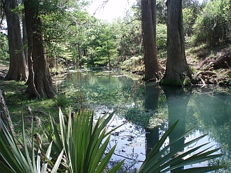
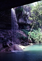
 WESTCAVE PRESERVE:
LCRA owned but privately operated (non-profit) 31 acre area that includes a lush, green, limestone-walled canyon with many rare and endangered plants, canopied by giant cypress trees and a 40-foot waterfall tumbling over fern-covered travertine columns into an emerald pool. Dedicated to sustaining this unique ecological treasure and offering it as a scientific and educational resource to the community. Guided trail tours, adult & school programs, birding, star watching, and other programs help to inspire greater environmental conservation and awareness.
WESTCAVE PRESERVE:
LCRA owned but privately operated (non-profit) 31 acre area that includes a lush, green, limestone-walled canyon with many rare and endangered plants, canopied by giant cypress trees and a 40-foot waterfall tumbling over fern-covered travertine columns into an emerald pool. Dedicated to sustaining this unique ecological treasure and offering it as a scientific and educational resource to the community. Guided trail tours, adult & school programs, birding, star watching, and other programs help to inspire greater environmental conservation and awareness.
Location: In SW Travis County (but Blanco County address), at 24814 Hamilton Pool Rd (FM-3238), Round Mountain. 830-825-3442. 15 mi N of Dripping Springs, W of Bee Cave. westcave.org
Portal Photo Gallery: Westcave Preserve
Back To >> TOP OF PAGE & MAIN INDEX or BEGINNING OF DIRECTORY LISTINGS THIS PAGE
IN THE HILL COUNTRY
Note: There are a huge number of parks at the city and county level that are not listed here, but some are included in our city or county Portal profile pages. For example, San Marcos has 21 parks.
Listed below is a small selection.
 BLUE HOLE REGIONAL PARK:
Village of Wimberley owned and maintained 126 acre park and famous swimming area, fed by the Jacobs Well spring. Offers hiking, camping, swimming, picnicking, ball fields, pavilion, amphitheater. See nearby Woodcreek for Jacobs Well.
BLUE HOLE REGIONAL PARK:
Village of Wimberley owned and maintained 126 acre park and famous swimming area, fed by the Jacobs Well spring. Offers hiking, camping, swimming, picnicking, ball fields, pavilion, amphitheater. See nearby Woodcreek for Jacobs Well.
For updates on hours of operation and water conditions, check this City website.Blue Hole
Friends of Blue Hole: friendsofbluehole.org.
Location: 512-847-0025; 333 Blue Hole Ln, Wimberley, TX 78676, just E of the downtown square, off Old Kyle Rd, near junction of FM-3237.
CYPRESS CREEK PARK: Travis County owned and operated. On NE arm of Lake Travis, with 15 acres. A favorite spot for camping, boating, swimming, fishing, picnicking. Main body of the park has a gently sloping waterfront. Boat ramp and cove provide easy access to the popular basin area of Lake Travis and other parks on Lake Travis.
Location: From the intersection of RR-620 and FM-2222 in Travis County, take FM-2222 (Bullick Hollow Road) W for 2 mi toward Volente. Park entrance on L, just before the intersection of Bullick Hollow Rd and FM 2769 (Old Anderson Mill Rd). Travis County Profile. See Portal Highland Lakes Profile.
DINK PEARSON PARK: Travis County owned and operated. On N shore of Lake Travis with 14 acres. Features: swimming, picnicking, boating, fishing, nature study, picnic tables, grills, unimproved boat ramp
Location: From Hwy 183 in Travis County, take FM 1431 S 11 mi to Lohmans Ford Rd. Turn L and travel 7 mi S toward Point Venture to park entrance. Travis County Profile. See Portal Highland Lakes Profile.
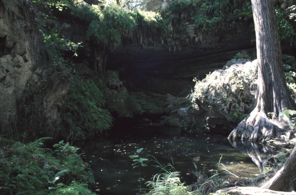
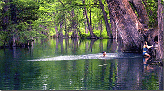
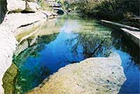
 HAMILTON POOL NATURE PRESERVE:
Travis County owned and operated. This 232-acre preserve is managed as a natural area (preserve) with emphasis on habitat protection and restoration, environmental education for public and private groups, and ongoing research. Offers limited, day-use only, with recreational opportunities such as picnicking, hiking, biking, swimming and nature study. The preserve's pool and grotto were formed when the dome of an underground river collapsed due to massive erosion thousands of years ago. There is a 45 foot water fall creating a great swimming hole. Nature trails along the creek. Swimming allowed only when the water quality meets safe standards. Water quality is monitored regularly. Updated information is posted at the entrance booth and provided on the park's telephone recorder message. Drinking water and concessions not available in the preserve.
HAMILTON POOL NATURE PRESERVE:
Travis County owned and operated. This 232-acre preserve is managed as a natural area (preserve) with emphasis on habitat protection and restoration, environmental education for public and private groups, and ongoing research. Offers limited, day-use only, with recreational opportunities such as picnicking, hiking, biking, swimming and nature study. The preserve's pool and grotto were formed when the dome of an underground river collapsed due to massive erosion thousands of years ago. There is a 45 foot water fall creating a great swimming hole. Nature trails along the creek. Swimming allowed only when the water quality meets safe standards. Water quality is monitored regularly. Updated information is posted at the entrance booth and provided on the park's telephone recorder message. Drinking water and concessions not available in the preserve.
Location: In Travis County, at 24300 Hamilton Pool Rd, 10 mi N of Dripping Springs, W of Bee Cave. 512-264-2740. co.travis.tx.us/tnr/parks/hamilton_pool.asp; Hamilton Pool
Portal Photo Gallery: Hamilton Pool Nature Preserve
JACOB'S WELL NATURAL AREA:
 This historic Trinity Aquifer natural artesian spring, known as Jacob's Well, has the longest underwater cave in Texas, and is roughly 140 feet below the surface. A favorite swimming hole. Jacob's Well flows into Cypress Creek 3 mi NW of Wimberley near Woodcreek. It flows from an inclined shaft 40 meters deep along a fault line in the Edwards Plateau. With layered limestone cliffs on one side, a vibrantly vegetated bank on the other and a lively riparian area alongside the creek, this gem of the Texas Hill Country has a way of enchanting visitors of all ages. In the past the 3 meter width of the shaft and the multi-chambered cave at its bottom attracted scuba divers. The well claimed several lives and has been closed to diving. In 1948 Woodcreek Properties made the well pond a part of its resort development. Jacob's Well and its watery cave figure as an important locale in Stephen Harrigan's 1984 novel of that name. Hays County owns and is responsible for the long-term stewardship of the 81 acre JWNA site. Free Sat tours at 10a and by appointment. Hosts public and private organizations. Access permitted only during tour hours. 1/4 mi hike from parking to the site. Annual festival in Sep.
Web: jacobswellspring.org; County Web Articles
Location: In west-centeral Hays County, in Woodcreek at 221 Wood Acre Dr, Wimberley, TX 78676.
Lat-Long: 30° 02' N, 98° 08' W. Info: 512 847-5999; 512-847-2140
KERRVILLE-SCHREINER PARK: Located on the Guadalupe River, this 517-acre park offers a host of activities including boating, fishing, camping, picnicking, unsupervised swimming in the river, bird watching, hiking, walking, and cycling. Open year-round, 8a to 10p for day use. Formerly a state park and now operated by City of Kerrrville. Elevation 1645 ft.
Facilities include restrooms with hot showers; day use picnic sites; campsites with limited and full RV hook-ups; mini-cabins, dump Stations; picnic areas, dining and recreation halls, an amphitheater, laundromat, concrete boat ramp, 8 mi of hiking trails, 6 mi of mountain bike beginner/intermediate trails, lighted fishing pier, playgrounds, and a convenience store. Reservations are recommended for campsites.
Location: In Kerr County, 5 mi SE of Kerrville at 2385 Bandera Hwy (Hwy 173), Kerrville TX 78028; Google Map; 830-257-5392. tpwd.state.tx.us/spdest/findadest/parks/kerrville_schreiner
Email: kerrpark@kerrville.org; www.kerrville.org/index.asp?NID=318; Reservations: kerrville.gov
LADY BIRD JOHNSON MUNICIPAL PARK: City of Fredericksburg owned and operated. A 190-acre park featuring fully equipped RV sites, golf, swimming, tennis, badminton, picnicking plus a small lake for sailboats, canoes, and pedal boats.
Location: In Gillespie County, 3.5 mi S of Fredericksburg, off Hwy 16, at 432 Lady Bird Dr, Fredericksburg, TX 78624.
Golf Course Pro Shop: 800-950-8147 or 830-997-4010; Park HQ: 830-997-4202
www.fbgtx.org/departments/ladybirdpark.htm
MILTON REIMERS RANCH PARK: Travis County owned and operated. This pristine 2,427 acre parkland, open space and reserve land in western Travis County with almost 3 mi of continuous frontage along the Pedernales River is the largest parkland acquisition in the history of Travis County. The sizeable Central Texas rock-climbing community views Reimers as a destination with world class rock climbing. The active local mountain biking community likewise enjoys over 18 mi of trails through the classic Central Texas landscape at Reimers. Local anglers have come to Reimers for generations to fish for white bass in the Pedernales River. The Pogue Springs Preserve/Hogge Reserve component of the land acquisition is less known but equally spectacular with Pedernales River frontage, deep canyons and panoramic views of the Texas Hill Country.
Location: In Travis County, at 23610 Hamilton Pool Rd, Bee Cave; 512-264-1923. co.travis.tx.us/tnr/parks/reimers_ranch.asp. See Travis County: Parks
Back To >> TOP OF PAGE & MAIN INDEX or BEGINNING OF DIRECTORY LISTINGS THIS PAGE
IN THE HILL COUNTRY
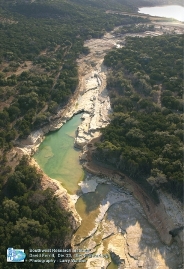
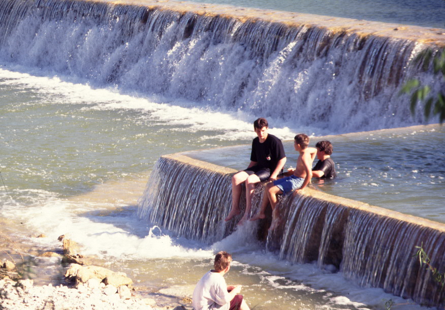
CANYON LAKE GORGE: The Power of Water!
Created by the torrential rains of 2002, this gigantic 64 acre gorge below Canyon Dam is managed by the Gorge Preservation Society and is now open to the public. Dramatic views. Waterfalls, geologic formations, beautiful lagoons, numerous springs and more! Guided tours only, at $10, 3 hours, weekend and weekday tours available, ages 7 & up, must pre register on the website
or by calling 830-964-5424
Web: canyongorge.org
Location: In Comal County at Canyon Lake at E end of lake below the dam. Tours start at Overlook Park, 601 COE Rd, Canyon Lake, TX. Park at the turnaround loop up by the restrooms, at the very end of COE Rd.
GPS coordinates: N 29° 51.620', W 098° 11.877'

CIBOLO NATURE CENTER: A 100 acre center. The hiking trails are laid out to bring the visitor through 4 dramatically distinct eco-systems. The creek, marshland, meadow and woods each have a unique charm, and each has its owns set of plant and animal life to observe. Named one of the top ten hikes in Texas by Texas Monthly Magazine. Educational center and bookstore in a restored historic building.
Location: In Kendall County, at 140 City Park Rd, Boerne, TX 78006
830-249-4616; cibolo.org
JACOB'S PARK: On N shore of Canyon Lake, in 2 parts, Park 1 and Park North. Both have docks and North also has camping facilities. Randolph Air Force Base (RAFB) facility.
Location: In Comal County at Canyon Lake. Off FM 306 on Jacobs Creek Park Rd.Google. Map. Coordinates: N 29.884°, W 098.219°
MEDINA LAKE, THOUSAND TRAILS, TEXAS PARK: This 260-acre preserve is a commercial park on the shores of Medina Lake. Hunting, boating and fishing. Golf course. Campsites: 220 full hookups, 167 power and water only.; Rentals: 7 trailers, 12 extended lease sites, 4 TT cabins, 6 Getaway cabins.
Location: In SE Bandera County and NE Medina County, at 215 Spettle Rd (at PR 37 & 8th St), Lake Hills, TX 78063; 800-480-5611;
reserveamerica.com/camping/Medina_Lake/r/campgroundDetails.do?contractCode=TRLS&parkId=210164&topTabIndex=CampingSpot; See Portal Profile

RIVERSIDE NATURE CENTER: Located in the heart of Kerrville on the Guadalupe River at the junction of Town Creek. This former small farm has been transformed into an urban wildlife and native plant sanctuary. It features a unique arboretum with over 140 species of trees as well as cacti, glorious wildflowers, shrubs, native grasses, birds, insects and other animals. Meandering walking trails lead you through the Nature Center gardens and down to the banks of the beautiful Guadalupe River. Explorer's lab for children, nature education programs, visitor center, and an historical general store.
Location: In Kerr County, at 150 Francisco Lemos St, Kerrville, TX 78028
830-257-4837. riversidenaturecenter.org
HIGHLAND LAKES (Buchanan, Inks, Marble Falls, LBJ, Travis, Austin, Lady Bird):
For detailed profiles of each, see Portal Highland Lakes Are Profile.
CANYON LAKE: See Portal Canyon Lake Area Profile
MEDINA LAKE: See Portal Medina Lake Area Profile
Note: See TPWD River Profiles: tpwd.state.tx.us/landwater/water/habitats/rivers
TEXAS RIVERS PROTECTION ASSOCIATION: txrivers.org; Facebook-TRPA. Concerned about the quality of our remaining natural rivers.
LCRA HYDROLOGIC DATA & MAP: hydromet.lcra.org/full.aspx. Excellent map of rivers in the Hill Country.
BLANCO RIVER: Handbook of Texas On-line
COLORADO RIVER (Texas): Handbook of Texas On-line; Wikipedia
COMAL RIVER: Handbook of Texas On-line
FRIO RIVER: Handbook of Texas On-line
GUADALUPE RIVER: Handbook of Texas On-line
LAMPASAS RIVER: Handbook of Texas On-line
LLANO RIVER: Handbook of Texas On-line, Llano River Watershed Alliance (Preserving and enhancing the rivers and springs of the Llano watershed through education, community participation, and collaboration), Facebook: Llano River Watershed Alliance
MEDINA RIVER: Handbook of Texas On-line; Wikipedia
NUECES RIVER: Handbook of Texas On-line
PEDERNALES RIVER: Handbook of Texas On-line. Pronounced "perd'n'alice". Video
SABINAL RIVER: Handbook of Texas On-line
SAN GABRIEL RIVER: Handbook of Texas On-line
SAN MARCOS RIVER: Handbook of Texas On-line
SAN SABA RIVER: Handbook of Texas On-line; Facebook - Friends of The San Saba River
A.E. WOOD (SAN MARCOS) NATIONAL FISH HATCHERY: Located along the banks of the San Marcos River. This state-of-the-art facility specializes in rearing fingerling sportfish for stocking into more than 300 Texas reservoirs. The staff welcomes the public to visit this educational and informative facility. General hatchery tours are offered to walk-ins at 10a and 2p Mon-Fri. Large groups (10 or more) are asked to call to set up a tour time. Manager: Robert Schmid, Email: rob.schmid@tpwd.state.tx.us Location: 507 Staples Road, San Marcos, TX 78666; 512-353-0572; tpwd.state.tx.us/fishboat/fish/management/hatcheries
INKS LAKE DAM NATIONAL FISH HATCHERY: Provides channel catfish and largemouth bass to Federal and Indian waters of the Southwest. Its mission has expanded to include the production of striped bass for restoration to the Texas gulf coast. Also helps restore paddlefish populations in the Mississippi River basin, and raises largemouth bass and channel catfish for sport fishing.
Location: Burnet, TX 78611; 512-793-2474. Located 10 mi W of Burnet on TX 29, then 6 mi S on Park Road 4, then R on Road 117 to hatchery. fws.gov/southwest/fisheries/inksdam.html
FACTOID: There are no national wildlife refuges in the Texas Hill Country.
Cave properties are typically managed as park facilities, but are profiled in the Portal on a separate page. See Bats & Bat Caves, and Caves & Caverns
Many of these are also featured in our Portal Photo Gallery.
Historic forts are typically managed as park facilities, but are profiled in the Portal on a separate page.
See Forts
CENTRAL TEXAS WATER COALITION: CentralTexasWaterCoalition.org. Mission is to advocate for and preserve the Highland Lakes’ role as an irreplaceable natural resource that drives an important regional economic engine for the State of Texas, and to bring together concerned citizens as a constituency of the Highland “Lake Interests”.
GUADALUPE BLANCO RIVER AUTHORITY: gbra.org
HILL COUNTRY NATURAL RESOURCES: Hill Country Natural Resources. Covers water, land, wildlife, conservation, management
HILL COUNTRY OUTDOORS: hillcountryoutdoors.com
LAKE TRAVIS BOATERS: 512-426-4662; laketravisboaters.com
LCRA HYDRLOGICAL DATA: hydromet.lcra.org/index2.shtml
SAN MARCOS RIVER FOUNDATIONsanmarcosriver.org
SEA TOW: 512-328-4869; 800-473-2869; 5975 Hiline Rd, Austin, TX 78734. Serves Lake Austin, Lake Travis, Lake LBJ, and Canyon Lake
TEXANS FOR STATE PARKS: texansstateparks.org. Austin-based advocacy group. Citizens working to preserve and enhance the state park system for the benefit of the people of Texas and their guests.
TEXAS RECREATION & PARK SOCIETY: traps.org
TEXAS STATE PARK FRIENDS GROUPS: tpwd.state.tx.us/spdest/friends_groups
WILD TEXAS: WildTexas.com. Guide to Texas parks, travel and outdoor recreation
Site designed, maintained & Copyright © by Cofran & Associates, Inc.All rights reserved
See Terms of Use before using this website.Cofran.comGeorgeCofran@Gmail.com281-300-7177
Click for Hill Country:
» MARKET DAYS
» ALL CALENDARS
» ATTRACTIONS
» ADVENTURES
» MAPS
Come share a piece of our world....
![]()
Family-owned winery
& vineyard operation
at a century-old
farm house,
breathtaking views
of Hill Country,
& handcrafted
Texas wines
830 998-7654
10352 US 290 W
Hye, Texas
williamchriswines.com
Affordable Pre-paid Emergency Air Transport Service

Click image for details
Protection starts at $65/yr

Protect Your Computer Files With![]()
On-Line storage
of your data.
Easy!
Just click
to get started.